A 6-Box Climate Model
IntroductionConstruction of the 6-Box Climate Model
1. Response Time
RETURN TO CLIMATE MODELING INTRO
Introduction
The two previous models of the global climate system are similar in the sense that they provide no spatial resolution; land at the equator is lumped together with land at the poles. Our next climate model makes a bit of a quantum leap by keeping track of the energy flows in different latitude zones. This type of a model is sometimes called a zonal energy balance model and it represents the precursor to the very sophisticated global circulation models (GCMs) that run on the fastest supercomputers. As will be seen, this model is quite a bit more complex than our previous ones in terms of design, but conceptually, it is almost the same, and in fact simpler in some respects because we do not keep track of the energy storage in the atmosphere.
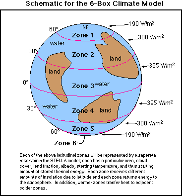
This model attempts to represent the spherical Earth in the form of 6 linked reservoirs -- the general picture is shown in the figure below:
Construction of the 6-Box Climate Model
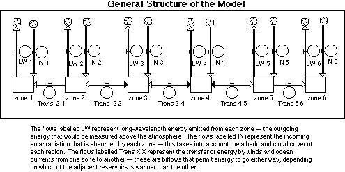
This schematic model is rather difficult to convert into a STELLA model -- we are pushing the limits of what STELLA can easily do. The figure below shows the structure of the model in two formats -- a generalized version to give you the overall sense, and then the complete version, in all of its glory.
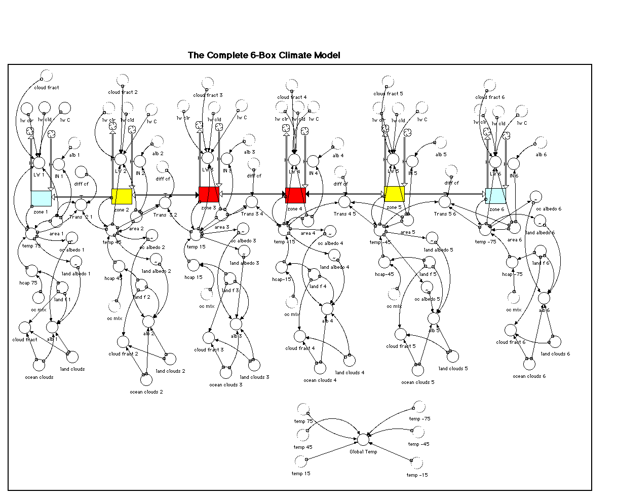
The complete STELLA model is shown below, enlarged to enable you to clearly see all of the components. Pay attention to the fact that many of the converters are "ghosts" or duplicate copies of a converter that are used to minimize the tangle of connecting arrows in the model diagram. To create a ghost, you must first create and define a converter, then select the ghost tool and click on the original converter; move the cursor (now in the symbol of a ghost) to a new position and click once to deposit the ghost converter.
Notes on Model Construction
Solar Input
The Solar Input for each zone depends on the composite albedo and the incoming solar radiation for that latitude zone, which varies because of the average angle between the Sun and the land surface. The equatorial regions, with the highest angle (Sun perpendicular to the surface) receive the highest intensity of energy flow, while the polar regions receive the lowest. The composite albedo depends on the amount of land and water in the zone and the overall cloudiness, as well as the temperature. The relationship between temperature and albedo varies slightly from zone to zone because the albedo is sensitive to the angle of the sun with respect to the surface (think about how mirror-like a calm body of water is in at sunrise and sunset).
Emitted LW Energy
The outgoing long-wavelength or infrared energy in this model is basically the difference between the energy emitted by the land and the atmosphere to space and the energy re-radiated to the land surface by the atmosphere. Here, we essentially combine two separate flows from our original climate model. The formulation in this model is empirical, meaning it is based on observations, and takes into account the cloudiness of each zone, and the temperature of each zone.
Heat Transfer Between Zones
Since this model has different latitude zones, there have to be flows between the reservoirs representing the transfer of heat from the equators to the poles, which is one of the major jobs of the atmospheric and oceanographic circulation. This cross-latitudinal heat transport is obviously a very complex process and depends on the details of continental positions and oceanographic currents. This model uses a heat diffusion coefficient that is basically another empirical constant; when multiplied by the temperature difference between adjacent latitude zones, this gives the intensity of energy flow (W/m2) from zone to zone. This coefficient is assumed to be the same between all zones.
The basic equation for each reservoir says that the change in thermal energy stored is the solar input plus heat added from adjacent zones minus the outgoing long-wavelength energy plus the heat exported to adjacent latitude zones. When the system is in a steady state, these energy flows balance.
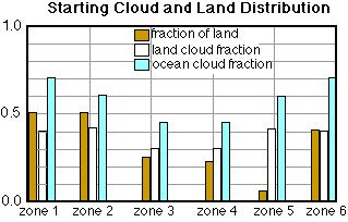
Cloud Cover and Land-Ocean Fractions of Zones
As can be seen in the figure below, this model also specifies the land and ocean fractions of each zone, as well as the cloudiness above land and ocean for each zone.
These data are based on observations and are intended to represent average conditions over the course of a year. In reality, the cloudiness is highly variable over the course of a year, so this model is not designed to study climate change on very short time scales. The model also includes some starting temperatures for each latitude zone; these also represent yearly averages for the present time.
DOWNLOADABLE 6-BOX CLIMATE MODEL
The equations and data for this model are presented below. With so many data to type in, it would be easy to make mistakes that prevent the model from working properly. As it is, the model is not in a steady state initially. It apparently has a hard time making the polar region in the southern hemisphere remain as cold as it actually is. But the system quickly finds a steady state in which most latitude zones are not too different from their starting temperatures. This steady state, achieved in about 10 years, will serve as a control for experiments with this model. For reference, running the this model for 20 years at a time step of 0.1 should produce a global temperature of 14.19°C.
Experiments
Because of the added complexity of this model, it does not lend itself so easily to the same kinds of experiments we have done with the previous model, but it does present some new and exciting experimental opportunities, a few of which are outlined below.
1. Response Time
This model, as outlined above, is not exactly in a steady state to begin with; the temperatures of the zones all change from their starting values. The system finds a steady state, however, allowing us to easily see the response time of this system, which can be compared to the other climate models we have worked with.
2. Importance of Land/Ocean Distribution
The locations of continents and oceans on Earth are continuously changing because of plate tectonics. With this new climate model, we can investigate how the distribution of land changes the global and regional climates. To do these experiments, we will have to modify the land fraction of each zone in such a way that the total area covered by land is more or less the same. The table below lists the land fraction distributions for four different worlds such that each world has the same total land area as the present world.
Present CapWorld BeltWorld UniWorld land f land f land f land f zone 1
0.5 1 0 0.2835 zone 2
0.5 0.407 0 0.2835 zone 3
0.26 0 0.567 0.2835 zone 4
0.23 0 0.567 0.2835 zone 5
0.05 0.407 0 0.2835 zone 6
0.4 1 0
0.2835
The Present case is our modern world, the starting condition for the model. CapWorld has all of the land mass located at the poles, BeltWorld has the land mass distributed around the tropics, forming a belt around the mid-section of the Earth, and UniWorld has an equal fraction of land in each zone (the terms CapWorld and BeltWorld come from the paper by Worsley and Kidder listed below). We should bear in mind that one thing we cannot account for in this model is how the locations of continents controls ocean circulation patterns, which control efficient the cross-latitudinal heat transport is -- represented by the heat diffusion coefficient in this model.
I would suggest that the simplest way of evaluating these changes is to insert the new land fractions and run the model until it reaches a steady state, then record the temperature of each zone to make a graph, using a different program or the old-fashioned way, with graph paper and a pencil, that plots the temperature against the median latitude of each zone (median latitude for zone 1 is 75; -75 for zone 6). These data could also be exported from STELLA to a graphing program by making a Table (icon next to the Graph icon) and plotting the zonal temperatures over time, then copying the ending set of data and pasting it into another program. In graphing these results, you may want to plot the data as differences relative to the zonal temperatures in the present world, the control in these experiments. The other parameter to look at is the average global temperature, which is a converter in the model.
Again, don't forget to make predictions before running these models. You may find it necessary to graph other parameters, such as the incoming and outgoing energy flows for the different zones; accounting for the differences between these models will require some careful thought. Do these results give you some insight into what kind of a world might be more susceptible to developing massive polar ice sheets?
3. The Glacial World
Earth's climate over the last 2 million years has been dominated by an oscillation back and forth between glacial periods and interglacials. Let's explore the glacial state using our model. For the sake of comparison, let's consider a few of the details. Our climate on the whole was probably on the order of 5 to 8°C colder than present, with some of the higher latitudes experiencing temperature drops of 10 to 15°C. It was long thought that the equatorial regions did not experience much of a temperature change at all, but recent studies of corals from the tropics indicate that these regions also cooled by as much as 4 to 5°C.
The question we need to consider next is how to change the model to represent a glacial world, with extensive ice sheets in the polar regions. For starters, we can change the cloud cover; the reasoning here is that with little exposed water, there will be little evaporation in these areas that could provide water vapor necessary to form clouds -- all of the water vapor has to come from sublimation or as imported moisture from lower latitudes. Let's make an estimate here, saying that the cloud cover is reduced to 20% or 0.2 for both land and ocean areas. The other thing we need to change is the albedo of both land and oceans in these two polar zones. At these high latitudes, ice covered with snow may have an average albedo of 0.7; for oceanic areas, let's say the albedo is a bit less, 0.6, figuring that sea ice near the lower latitude parts of these zones breaks up periodically, exposing darker water for part of the time. If these zones are already covered by big ice sheets, they are not going to melt significantly over the 10 or 20 years we'll run this model to get it into a steady state; a big energy boost is needed to melt the ice, and this reality is not accounted for in the model. This means that we need to ensure that the albedo for land and ocean areas for these two zones does not change over this time period; the graphs for these albedos therefore can be drawn as straight lines so that they are at constant values.
These modifications are a first attempt to represent the glacial world. Make a prediction and then run the model to see what kind of a steady state results. As discussed above, a good way to look at your results is in a graph showing the departures in temperature from the control for each zone. How does our simulated glacial world compare with the real glacial world? If the match is not too good, try to think of some other changes you could make to the model to produce a stronger cooling of the equatorial region. One thing to consider is that some recent studies indicate that the glacial world may have had a much drier atmosphere, with perhaps as little as 20% as much water vapor as at present. Remember that water vapor is our major greenhouse gas and it is also necessary to form clouds.
4. Volcanic Eruptions
As a means of understanding the importance of where clouds occur, we'll model the effects of three hypothetical volcanic eruptions that inject large quantities of ash and other aerosols that block sunlight; each eruption occurs within a different zone and its cloudiness effects are limited to the zone where the eruption occurs. We'll make these eruptions pretty severe, so that they increase the cloudiness to 100% for a period of 4 years and then return to their former levels.
The three eruptions will occur in zones 1 through 3. The strategy for modifying the model is fairly simple -- make the land cloud and ocean cloud converters be graphical functions of time, then put a plateau in the cloudiness beginning a the time of the eruption and ending after 4 years. Let's make the first eruption occur in zone 1, the high latitude part of the northern hemisphere --this could be like the large Icelandic eruption of the late 1700s that caught the attention of Ben Franklin. We want the eruption to occur after the system has reached its steady state, after about 10 years. So, double-click on the land clouds 1 converter and make it equal to time and then click on the Become Graph button. Set the time ranges to 0 on the low end and 20 on the high end, set the land clouds range from 0 to 1; make sure the graph has 21 data points. Create the graph by setting the background level to 0.4 and then putting a plateau that jumps from 0.4 to 1.0 between time 10 and 11, then hold it constant at 1.0 until time 13 and then returning it to 0.4 at time 14. Do the same for the ocean clouds 1 converter. This change amounts of a 45% increase in the cloud cover for this zone; multiplying this by the total area in the zone gives the total area of new cloud cover. For the other eruptions, in the other zones, we want to try to make the total area of new cloud cover equal to that of the first eruption -- this will facilitate a better comparison of the three eruptions since they will effectively be of the same size. For the second eruption, we need to increase the cloud cover of zone 2 by 16.6%; this can be done by adding 0.166 to the land clouds 2 and ocean clouds 2 converters. As in the first eruption, this change can be made by making each of the converters a graphical function of time, and making a plateau that begins in year 10 and ends in year 14. The third eruption can be modeled by 0.12 to the land clouds 3 and ocean clouds 3 converters. For each eruption, be sure to return the other zones to their original conditions so that you've only go one eruption going on at any one time.
In making your predictions, think about how each eruption is likely to affect not just the zone it occurs within, but also adjacent zones -- how widespread are the effects? The other things to consider are the magnitude of the temperature change -- locally and globally -- and the amount of time needed for the system to return to a steady state. Bear in mind that these are some enormous eruptions, so the effects may be impressive.
5. Importance of Heat Diffusion Coefficients
You may have noticed that our initial model is not stable with the starting temperatures and it quickly evolves into a steady state that is characterized by relatively small temperature changes for most of the zones, with the exception of zone 6, the region dominated by Antarctica. Zone 6, in the model, has a difficult time staying cold and one possible explanation is that the heat diffusion coefficient should not be the same for this zone as for the rest of the globe. In this area, there is a powerful circulation system in the atmosphere and oceans that make a ring around Antarctica, effectively isolating it from the warmer, lower-latitude regions. Part of the reason this circum-Antarctic circulation exists is that there are not continental masses blocking or altering flow at these latitudes; the case is very different in the northern hemisphere. We can attempt to simulate this feature of the modern climate by altering the heat diffusion coefficient that controls the transfer of heat from zone 5 to zone 6. If we simply change the value of the heat diffusion coefficient converter in the model, it changes for all heat transfers, and we only want to alter the transfer from zone 5 to zone 6. To do this, double-click on the flow called Trans 5 6, put parentheses around diff c and inside those parentheses multiply it by 0.75; this will reduce the heat diffusion coefficient acting on this flow from a value of 3 to a value of 2.25. Reducing this coefficient reduces the amount of energy transferred from zone 5 to zone 6, so this should have the desired effect. Before running the model, think about how this change will affect zones 5 and 6, and also the rest of the model.
Now let's do a more general experiment, one in which we change the heat diffusion coefficient for the whole system. For the present world, the value of the heat diffusion coefficient is related to the vigor of oceanic and atmospheric circulation. What changes the vigor of circulation? A variety of factors contribute, including: the water vapor content of the atmosphere, which controls the heat-carrying capacity of the atmosphere; the pattern of ocean circulation, which is controlled by the locations of the continents; the pole-to-equator temperature gradient, which controls the average wind velocity; and the rotation of the planet, which controls the Coriolis effect. We can investigate the climatological effects of both increasing and decreasing the vigor of the system by first doubling and then halving the coefficient and examining the response of the system. As before, a good way of looking at the results is to et the system come to a steady state and then take the ending zonal temperatures, export them to a graphing program and compare them with the steady state zonal temperatures of the initial model, the control. You may also want to plot the differences in zonal temperatures between the control and these modified models. It will also be interesting to compare the average global temperatures of the various models and the control.
Summary
In this chapter, we have explored the dynamics of the global heating system, a simple version of the global climate system. This is an energy flow system that is powered by solar energy and is characterized by relatively large flow-to-reservoir ratios, leading to a short response time. This system is filled with strong negative feedback mechanisms that drive it to a steady state in which the incoming energy is balanced by the outgoing energy. Altering a wide variety of components of this system cause a rapid response and a shift to a new steady state, which generally means a new set of temperatures for the reservoirs in the system. Although the system is loaded with negative feedbacks, it is sensitive to changes; a 1% change in the solar input produces a fairly significant (by our standards) temperature change at the surface.
In constructing these models, some care was given to finding and using the right data; as a result, these models give a fairly good representation of how the global climate changes in response to variables. For instance, when we put in the expected effect of doubling the atmospheric CO2, the land surface warmed by an amount that is in good agreement with the most sophisticated computer models available. The model also produces a fairly realistic time lag between seasonal changes in solar input and the peaks and troughs in the land surface temperature. For these reasons, we have some cause to think that this models produces results that are at least qualitatively reasonable.
It is important to understand that the first two versions of climate models used here treat the whole globe as just one or two reservoirs; they make no geographic or spatial distinctions, and as we are all aware, the climate can and does vary significantly on these smaller scales. We made a step in the direction of spatial resolution with our last model, in which we separated the planet into 6 different latitude belts. To go much further, to take the next step in spatial resolution would require the construction of a model with a multitude of reservoirs that are arrayed in a three-dimensional grid -- this is how the big general circulation models (GCMs) are constructed. But at their hearts, these very large GCMs are very similar to these box-models we have experimented with in this chapter. So, your experience with these simple climate models gives you some insight into the workings of these state-of-the-art models.
Even with the simplest model, we have touched on some of the most important questions in climate modeling. The exact role of clouds and how cloudiness will change with global temperature is one of the outstanding questions, and we have seen how different assumptions about this role of clouds results in very different responses of the system to an enhanced greenhouse. We have also explored the important question of distinguishing the causes of global warming -- we saw that it is in fact possible to distinguish between global warming caused by an increase in the solar output and warming caused by an enhanced greenhouse. So in theory, this important question can be resolved, but in practice, the big problem is in collecting the appropriate data and seeing through the noise in the data.
References