 , (1)
, (1)
MESOSCALE CONVECTIVE SYSTEMS
J. M. Fritsch and G. S. Forbes
Department of Meteorology
Pennsylvania State University
University Park, PA 16802
Submitted to
American Meteorological Society Monographs
11 February 1997
(2nd revision January 1999)
Corresponding author address:
J. M. Fritsch
Dept. of Meteorology
503 Walker Bldg.
Penn State University
University Park, PA 16802
email address: fritsch@ems.psu.edu
fax: 814-865-3663
phone: 814-863-1842
1. Introduction
According to Zipser (1982), a Mesoscale Convective System (MCS) is a weather feature which exhibits moist convective overturning contiguous with or embedded within a mesoscale circulation that is at least partially driven by the convective processes. Such a broad definition includes a wide variety of mesoscale phenomena ranging from short-lived indiscriminate aggregates of a few thunderstorms to well-organized squall lines to long-lived tropical storms and even hurricanes.
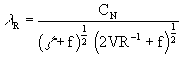
Because of the broad temporal and spacial spectra of MCSs, it is neither possible nor desirable to try to discuss here all systems that fit under the MCS-definition umbrella. Rather, we choose to concentrate on the largest portion of the spectrum of MCSs, excluding, however, tropical storms. This would include systems which are dynamically mesoscale, i.e., systems with a Rossby number of order 1, and systems with a radius comparable to the Rossby radius of deformation lR (Schubert et al. 1980; Cotton et al. 1989) where
, (1)
z
is the vertical component of relative vorticity, f is the coriolis parameter, CN is the phase speed of an inertia-gravity wave, and V is the tangential component of the wind at the radius of curvature R. For such systems, both ageostrophic advection and rotational influences are important ( Lilly and Gal-Chen 1983). Cotton et al. (1989) found that, for midlatitude MCS environments, l R is about 300 km. For midlatitude systems of this scale, it typically takes about 3 to 6 h for Coriolis influences to become significant. Moreover, Cotton et al. also demonstrated that mesoscale convective complexes (MCCs), a subset of mesoscale convective systems which exhibit a large, circularly-shaped (as observed by satellite) long-lived cold cloud shield, typically fulfill these dynamical criteria. Likewise, as shown by Skamarock et al. (1994) and Davis and Weisman (1994), some large, long-lived squall lines also satisfy these dynamical criteria and, not surprisingly, exhibit dynamical properties similar to those of MCCs. Consequently, the material selected for this chapter will concentrate on the properties of MCCs but will also occasionally include some discussion of large MCSs and squall lines.Following Maddox (1980), the definition of an MCC is based on satellite imagery and requires that the convective system's cold cloud shield exhibit certain characteristics (Table 1). Principally, the system's cold cloud shield must surpass a size threshold, persist above the threshold size for at least 6 h, and exhibit a nearly circular shape at the time of maximum extent. Lifecycle phases for MCCs are similar to those defined by Maddox (1980) and Zipser (1982) and are defined in Table 2. Systems are categorized into two types, depending upon the dynamical mechanism whereby the convection and the large cold cloud shields, characteristic of MCCs, are produced. Type 1 events result when a mesoscale ribbon of low-level potentially unstable air is forced to ascend in a frontal zone or other baroclinic region (e.g., a warm or stationary frontal overrunning situation). Type-2 events occur in more barotropic environments and depend on the moist-downdraft production of a surface-based cold pool and its interaction with the ambient vertical wind shear to produce mesoscale ascent and the associated large stratiform cloud shield characteristic of MCCs. The distinction between these two types of events is that type-1 systems form and develop largely as a consequence of externally-imposed forcing (e.g., by mesoscale components of synoptic-scale baroclinic systems such as fronts) whereas type-2 systems depend more strongly on features and processes imposed by the convection itself (e.g., the moist-downdraft-generated mesoscale cold pool). These two types of events are discussed more fully in later sections.
The definition of a squall line is far broader than that of an MCC and includes many events that would not satisfy the condition that their length scale is comparable to l R. For example, Bluestein and Jain (1985) used radar-based criteria to identify squall lines in a study of springtime events in Oklahoma. They defined a line as a group of related or similar convective precipitation echoes that form a pattern exhibiting a length-to-width ratio of at least five-to-one. Lines had to be at least 50 km long, less than 50 km in width and persist for at least 15 min. Similarly, Hane (1986), in a review and summary of the structure and dynamics of extratropical squall lines and rainbands, pointed out that usage of the term 'squall line' has been generally applied to any line of thunderstorms, with or without squalls (Bluestein and Jain noted that some squall lines may not even contain buoyant elements!). It is not surprising then that, based on the results of Bluestein and Jain (1985) and Bluestein et al. (1987), lines are three to five times as common as MCCs and exhibit a great breadth of scales and physical processes. These broadly-based squall line definitions can result in overlap with the MCC definition since many, but not all, MCCs contain lines of thunderstorms. Visible satellite images of several squall lines and an MCC are shown in Fig. 1.
2. Climatological Characteristics
Mesoscale convective complexes tend to cluster in favored locations around the world. This tendency is most easily seen by examining their global distribution ( Fig. 2 ). From this distribution, it is evident that:
i) most MCCs occur over land,
ii) development occurs in zonally-elongated belts of easterlies or westerlies, and
iii) most populations are downstream (typically within 1500 km) of north-south mountain ranges.
It is particularly interesting that MCCs rarely occur in several regions where deep moist convection is extremely common, eg., the southeastern U.S. and the Amazon River Basin. However, these regions do commonly experience squall lines (Kousky 1980, Greco et al. 1992, Garstang et al. 1994).
One of the more intriguing aspects of MCCs is that all populations are predominantly nocturnal (Maddox 1980, Velasco and Fritsch 1987, Miller and Fritsch 1991, Laing and Fritsch 1993a,b). First thunderstorms usually develop in the mid-to-late afternoon and then increase in areal coverage as sunset approaches. The attendant cold-cloud shield typically attains MCC initiation size in the early nighttime hours, reaches maximum extent after midnight and dissipates a few hours after sunrise. Figure 3 shows the life cycle distribution for the global population (Laing and Fritsch 1997).
Although some MCCs produce cold cloud shields that extend over a million km2, most systems are about one third of this size ( Fig. 4 ). Also, as expected, the size and duration of MCSs and MCCs are positively correlated, i.e., larger systems tend to last longer (Tollerud et al. 1992, Laurent 1996, Laing and Fritsch 1997, Fig. 5 ). The typical MCC cold-cloud shield equals or exceeds the 105 km2 threshold for around 11 h, although some systems have continued for up to 36 h. The large contiguous cloud shields sometimes form from mergers of several initially distinct meso-g and-b scale elements while in other instances they simply grow from a single convective system (Houze et al. 1990).
A distinguishing factor in the longevity and size distributions of MCSs appears to be the strength of the early growth. The critical importance of the early growth was quantified by Tollerud et al. (1992) in their analysis of the relationship between early growth rates and cold cloud shield size. They found that the growth rate of the cold cloud shield in the first three hours of the life cycle of an MCS was a strong predictor of the eventual size and duration of the system (Fig. 5 ). Similarly, McAnelly and Cotton (1986, 1989) identified a meso-b-scale convective cycle that occurs early in the growth phase and argue that it distinguishes between the early stage evolution of an MCC and other shorter-lived MCSs.
The early growth period also appears to be the most crucial time for the development of severe weather (high wind, tornadoes and hail). For example, in an analysis of 12 nocturnal MCCs, Maddox et al. (1986) found that over 80% of the severe weather occurred during the initiation period. Likewise, in a comprehensive analysis of Oklahoma mesoscale convective precipitation systems, Houze et at (1990) found that tornado and hail reports were biased toward the early stages of the systems' development. Similarly, Tollerud and Collander (1993a) investigated 350 MCCs that occurred in the U.S. during the ten-year period 1978-87 and found that an overwhelming fraction of the severe weather occurs in the initiation phase ( Fig. 6 ). On the other hand, nearly half of the severe wind reports occur during the developing and mature stages. Although it is not known what fraction of the global population of MCSs produces severe weather, about half of the systems that occur in the central U.S. exhibit some type of severe activity (Houze et al. 1990). Of this number, about twice as many severe events occur in linearly-organized systems compared to the more circular MCCs (Tollerud and Bartels 1988). Nevertheless, as shown in Table 3, U.S. MCCs are prolific producers of severe events. Moreover, Maddox (1980) points out that one in every five MCCs produces injuries or death.
Although severe weather tends to occur in the initiation phase of the lifecycle of MCSs, the heaviest rainfall generally occurs in the development phase (the period between the time that the cold cloud shield reaches Maddox's criteria for MCC initiation and the time of maximum extent; see Table 1 and Fig. 3 ). McAnelly and Cotton (1989), in a study of 122 MCCs, found that the peak average precipitation rate usually happens after initiation but several hours before the rain area and volumetric rain rate reach their maximum values ( Fig. 7 ). Likewise, Collander's (1993) investigation of the hourly precipitation associated with 350 MCCs showed that the maximum frequency of observations of heavy rainfall (amounts 25 mm h-1) most commonly occurs during the period 2 to 6 h after initiation ( Fig. 8 ). As shown in several studies (Kane et al. 1987, McAnelly and Cotton 1989, Collander 1993), these large rain rates and heavy rainfall amounts most frequently occur on the equatorward flank of the cold cloud shield. For example, Fig. 9 shows the mean precipitation for 74 U.S. MCCs. Clearly, the heaviest amounts favor the southwestern quadrant. And, as expected, the distribution of hourly heavy rainfall observations also shows a maximum in the southwestern flank ( Fig. 10 ).
In an analysis of the hourly-precipitation data for the ten-year period 1978-87 for the plains region of the U.S., MCCs accounted for 20 to 40 % of the record hourly rain rates during May through August even though they only accounted for less than 7% of the total number of observations of measurable rain (Tollerud and Collander 1993b). Thus, MCCs produce extreme rainfall at a rate far greater than that produced by other types of weather systems. This agrees with previous studies (eg., Simpson and Woodley 1971, Simpson et al. 1980; 1993) that have shown that precipitation efficiency and rain rates increase significantly as individual deep convective clouds merge into mesoscale convective systems. Finally, it is important to note that the total rainfall from two or three MCCs, or even a single large MCC, can rival and even exceed that from landfalling hurricanes and tropical storms (Fritsch et al. 1986).
3. Large-scale environment
Analyses of many MCC events (eg., Maddox 1983, Merritt 1985, Kane et al. 1987, Cotton et al. 1989, Augustine and Howard 1991, Laing 1996) show that certain thermodynamic patterns and dynamical features are usually present in their large-scale environment. For example, inspection of the mean synoptic environment for twelve U.S. MCCs ( Fig. 11 ) reveals that these large convective systems form in the vicinity of the terminus of a low-level jet that is supplying high-qe air to the MCC genesis region (Augustine and Caracena 1994). The jet is oriented nearly perpendicular to a pronounced horizontal thermal gradient and slopes upward as it overruns a surface-based layer of cooler air (Trier and Parsons 1993, Augustine and Caracena 1994, Rochette and Moore 1996). A weak mid-level short wave is approaching the genesis area and enhances the low-level convergence associated with the low-level jet (Maddox 1983, Cotton et al. 1989). Warm advection dominates the lower troposphere while diffluence is the rule at high levels. As shown by Laing (1996), the large-scale environments of other MCC populations around the world are generally very similar to the U.S. environment.
The pattern shown in Fig. 11 is not a particularly unusual one and could be observed over most midlatitude regions of the globe. Therefore, it is of special interest why this pattern results in MCCs only in certain regions and why these exceptionally large convective systems tend to occur at night. It has been argued that the nocturnal lifecycle of convective systems may be related to the differential radiative heating between the convective cloud area and its environment, i.e., cloud tops cool while the subcloud layer warms relative to the surrounding clear air. This would tend to enhance environmental subsidence on the periphery of the cloud shield and thereby increase low-level convergence into the system (Gray and Jacobson 1977). In support of this argument, Webster and Stephens (1980) and Chen and Cotton (1988) found that radiative cooling at cloud-top and warming at cloud base reduced the static stability of the stratiform anvil of mature MCSs. However, free-troposphere long wave cooling is typically small (< 0.1 degree C h-1; Dopplick 1972, Machado and Rossow 1993) compared to the convective heating rates observed in mesoscale convective systems (approximately 5 degrees C h-1; Ogura and Chen 1977) and, considering that MCCs exhibit intense and massive convective overturning for many hours, it is highly unlikely that local free-troposphere radiatively-driven circulations can create CAPE fast enough to offset the rates at which it is consumed in MCC overturning. Moreover, since cloudy/clear radiative forcing occurs everywhere, but, as noted above, some regions of the globe exhibit plentiful deep convection but few nocturnal MCSs, the nocturnal life cycle of MCCs must not be directly tied to the diurnal radiation cycle but rather must be indirectly connected through dynamical processes. Thus, there must be certain synoptic or mesoscale processes and circulations, strongly linked to the radiative cycle, that either locally and rapidly create huge amounts of CAPE via horizontal advection and vertical motion, or act to overcome convective inhibition (Colby 1984, Keenan and Carbone 1992) that has prohibited release of CAPE generated during daytime heating.
Since MCCs tend to be clustered in certain favored regions of the world ( Fig. 2 ), the diurnal processes and circulations that support their nocturnal lifecycle may be related to the physiography of the favored regions. Such a regional favoritism is not unusual for weather phenomena. For example, it is well known that tropical cyclones only occur in areas where the sea surface temperature exceeds 26 degrees C (Gray 1979). Even extratropical cyclones have favored locations due to local reductions in stability as a result of surface fluxes (Sanders and Gyakum 1980). It is also well known that certain mesoscale weather features have pronounced diurnal cycles. For example, mountain-valley and seabreeze circulations favor daytime convective events (Burpee 1979, Cooper et al. 1982). Therefore, it is not surprising that there is a strong correlation between the nocturnal MCC population centers and regions which experience a high frequency of nocturnal low-level jets of high-qe air (eg., Maddox 1983, Velasco and Fritsch 1987, Miller and Fritsch 1991, Augustine and Caracena 1994).
According to Blackadar (1957), Holton (1967), Bonner (1968), Paegle (1978), McNider and Pielke (1981) and others, nocturnal low-level jets develop as a result of adjustments that take place as 1) the mixed layer decouples from the surface as the surface cools and 2) horizontal temperature differences develop as a result of sloping terrain (eg., the Great Plains) and an east-west gradient in the Bowen Ratio (ratio of surface sensible to latent heat flux). In as much as these processes are independent of the dynamics of traveling disturbances, the low-level wind accelerations that they produce provide a significant enhancement to the low-level warm advection and convergence that would normally be present as a result of an approaching short wave and/or a synoptic scale circulation (eg., the return flow from the Bermuda High). Because the jets typically are confined to the lowest 100-150 mb above the ground, the high-qe air that they transport can more readily underrun colder air aloft compared to what would occur with a deep tropospheric disturbance alone. This buildup of convective instability is further enabled by the necessity of veering wind direction with height in warm-advection flow that is approximately geostrophic in direction. The westerly component of flow above the core of the low-level jet necessitated by this warm advection often advects a capping drier residual layer of low static stability over the low-level high-qe air, enabling this underrunning. Further, in the typical traveling disturbance, the warm advection extends to higher levels than that associated with physiographically-produced low-level jets, thus making it more difficult to destabilize the environment via differential advection or vertical motion. The 'advantage' of nocturnal low-level jets to destabilize the atmosphere by underrunning meridional temperature gradients is obviously enhanced in regions where mid-level baroclinic environments are present. It is noteworthy that MCCs tend to be concentrated in latitudinal belts of easterlies or westerlies where baroclinic conditions prevail. Moreover, considering that the processes leading to the formation of low-level jets are inherently ageostrophic, the development of MCCs may be limited geographically generally to those regions in which such ageostrophic features can frequently be produced.
In addition to the underrunning of cold air aloft, Augustine and Howard (1988), Trier and Parsons (1993) and Augustine and Caracena (1994) have shown that pronounced low-level convergence occurs in the terminus region of developing low-level jets and that the vertical motion from this convergence contributes significantly to destabilizing the local environment prior to the onset of deep convection. Moreover, Tripoli and Cotton (1989) have shown how mountain/plains solenoidal circulations provide still additional forcing in the region downwind of mountain barriers. Therefore, when the processes that form low-level jets and the mountain/plains solenoidal circulations phase with favorable synoptic scale circulations (eg., overrunning of a quasi-stationary front) and with the forcing from an approaching short wave, exceptionally large destabilization rates can occur for several hours. As demonstrated by Augustine and Caracena (1994), the lifting and destabilization are especially strong when a low-level jet intersects the thermally direct circulation associated with frontogenetic forcing (Sawyer 1956). The magnitude and rate of production of CAPE in such situations can be far greater than that which occurs in other areas of the world where the regional physiographic features do not support the development of nocturnal low-level jets and destabilization must occur from direct radiative effects and/or from the quasi-geostrophic forcing of traveling disturbances and synoptic features alone.
Trier and Parsons (1993) explored these issues when they investigated one of several MCCs that occurred during the Oklahoma-Kansas PRE-STORM field program in 1985. (The PRE-STORM program was specifically designed to observe the structure and dynamics of mesoscale convective weather systems; see Cunning 1986.) The case that they investigated formed in an environment that was very similar to the mean MCC conditions shown in Fig. 11. They utilized the PRE-STORM high-density sounding network to construct a north-south cross section ( Fig. 12 ) through an east-west quasi-stationary front. The cross section was constructed using soundings taken approximately two hours before a developing MCC moved into the region. Their analysis clearly shows an upward-sloping low-level jet overrunning the quasi-stationary front and underrunning a north-south mid-tropospheric potential temperature gradient. As the system moved through the region, the strongest convective overturning occurred near Pratt, Kansas (station PTT in Fig. 12 ). The effect of the low-level jet on the stability at Pratt, just prior to the arrival of the system, is shown in Fig. 13. Note that the low-level qe values increased over 20 degrees in 90 min while mid-level values increased only marginally.
As noted above, an important feature in the typical MCC genesis environment is a surface-based frontal or baroclinic zone ( Fig. 11 ). This feature facilitates slantwise ascent of the lowest few hundred mb of warm sector air. Portions of the overrunning layer eventually saturate and scattered deep convective overturning ensues over a broad zone, typically several hundred km in the along-front direction (e.g. Figs. 14a,b and Figs. 15a,b ). In some instances, the saturated slantwise ascent contributes to the production of the large cold cloud shields characteristic of MCCs (eg., Fig. 15 and Smull and Augustine 1993). These frontal overrunning type of events will hereafter be referred to as type-1 events.
Although the formation of most MCCs occurs in conjunction with frontal lifting, a significant number of events occurs in warm sector environments without the benefit of the synoptic-scale frontal forcing (Kane et al. 1987, Johnson et al. 1989, Geldmeier and Barnes 1997). These events rely on the formation of surface-based moist-downdraft-generated cold pools originating from deep convective storms typically rooted in a well-mixed boundary layer to provide the layer lifting and slantwise ascent characteristic of MCCs. These events will hereafter be termed type-2 events. As shown by Rotunno et al. (1988), Weisman et al. 1988, and Weisman (1992), convective overturning in type-2 events tends to slope downshear, upshear, or remain upright, depending upon the relative strengths of the low-level vertical wind shear (D u) and the downdraft-generated cold pool ( Fig. 16 ). Typically, these three states of slope represent stages in the lifecycle of the convective system, as the cold pool tends to strengthen over time. Significantly, it isn't until after a mature cold pool develops that the slantwise front-to-rear ascent, characteristic of the flow that produces much of the MCC cold cloud shield, begins to appear ( Fig.17 and 17 contd. ).
Following Weisman (1992), the strength of the cold pool (C) is obtained by integrating the buoyancy (B) over the depth (H) of the cold pool. Thus, the cold pool strength can be expressed as
, (2)
where
![]() , (3)
, (3)
q
is the potential temperature, and qv, qc, and qr are the mixing ratios of water vapor, cloudwater, and rainwater, respectively. According to Rotunno et al. (1988), the 'optimal' situation for producing long-lived squall lines occurs when the ratio (s) of the cold pool strength to the shear is equal to one, i.e.,![]() , (4)
, (4)
where the shear is for the layer corresponding to the depth of the cold pool. (Note that this formulation ignores the non-negligible v-component of the shear.) The optimal state is the one which produces the deepest lifting at the leading edge of the cold pool,and, thus, is the state where the cold pool is most readily able to continually retrigger deep convective cells. In those instances where s 1, the system tilts upshear and forms a slantwise front-to-rear flow resembling the frontal overrunning within typical MCC environments ( Figs. 16, 17 and 17contd.). This slantwise circulation produces a large cold cloud shield reminiscent of that produced by MCCs. Similar structures and circulations were obtained by Fovell and Ogura (1989) in their two-dimensional simulations of multicell convective storms. Interestingly, the same structures and circulations were also produced by Pandya and Durran (1996) by introducing a steady thermal forcing into a dry simulation. The thermal forcing was scaled and structured to duplicate the latent heat released in a simulated moist convective line, i.e., the latent heating and cooling structure which they prescribed already represented the mature upshear-tilted feature which results from the cold-pool circulation overwhelming the ambient shear as evident in Figs. 16 and 17. Significantly, they did not obtain a realistic flow field when they used a vertically stacked heating and cooling pattern. Nevertheless, their results suggest that the 'far field' circulation of squall line/MCC type systems is the result of gravity waves forced primarily by the low-frequency components of the latent heating and cooling in the leading line. Schmidt and Cotton (1990) and Mapes (1993) also present evidence that gravity waves play a key role in shaping the structure and circulation of mesoscale convective systems, even in events where there is no surface-based well-mixed layer. In particular, using numerical simulations, Schmidt and Cotton (1989,1990) explored a derecho-like event wherein the environment was characterized by an absolutely stable surface-based layer (generated by previous convection) overrun by a moist well-mixed layer. Their results show how the propagation of the convective system was the result of gravity wave propagation within the surface-based stable layer and that the wave propagation was very sensitive to vertical wind shear.
It is interesting to compare the MCC and squall line environments within the framework of the Rotunno et al. (1988) conceptual model for long-lived convective systems. Recall that, within this framework, the vorticity of the ambient shear opposes and nearly balances the vorticity of a convectively-generated surface-based cold pool in order for long-lived squall lines to occur ( Fig. 18a ). Typically, the cold pool is generated locally by two main branches of moist downdrafts: 1) the up-down branch which initially ascends from the pre-storm low-levels and then descends within the precipitation region, and 2) the mid-level branch which originates from above the boundary layer and descends within the precipitation region (See Fig. 17 , 17 contd. and Knupp and Cotton 1985, Knupp 1987). The environment of the cold-pool-forced squall line events differs from the type-1 MCC environment in a number of important ways. First, in the type-1 MCC event, the convection originates from an elevated layer of high-qe air overrunning a quasi-stationary surface-based frontal zone ( Fig. 18b ). Therefore, a moist-downdraft-generated cold pool is not necessary to lift a layer of conditionally unstable air to saturation. Moreover, analyses of frontal events reveal that the moist downdrafts from the deep convective elements that develop from the frontal overrunning sometimes do not penetrate through the large-scale low-level layer of cold air to the surface (Fortune et al. 1992, Smull and Augustine 1993, Trier and Parsons 1993). Although mesohighs sometimes still form, the cold pool strength (as indicated by the temperature difference between the moist downdraft air and the ambient environment) is much weaker than in type-2 events. This is especially true for the portion of the cold pool associated with the mesoscale rain areas (see Loehrer and Johnson 1995, Kain and Fritsch 1998). Therefore, the concept of ambient vorticity (associated with vertical shear) opposing buoyancy-generated cold pool vorticity is not as readily applicable as in some warm sector (type-2) environments.
A second important difference between the typical MCC environment and the squall line conceptual model is the configuration of vertical wind shear relative to the orientation and direction of propagation of the deep convection. In the squall line model, the shear-induced vorticity opposes the cold-pool-induced vorticity ( Fig. 18a ). However, in the MCC environment, as a consequence of the low-level jet, the ambient shear in the cold-pool layer has the same sign as that which would be expected from any convectively-generated cold pool that would develop ( Fig. 18c ). According to Rotunno et al. (1988) and Weisman (1992), this arrangement of shear and cold-pool-induced vorticity would tend to produce slantwise upshear ascent and a large stratiform cloud layer. An additional but as yet unexplored factor is the effect of the stronger veering in the more baroclinic type-1 events compared to the weaker directional shear in the type-2 events.
The presence of the strong warm advection characteristic of MCC environments in general suggests that, in addition to the interaction of the convectively-generated cold pool with the ambient shear, the large-scale environment itself can contribute significantly to the slantwise ascent that comprises the stratiform cloud region. Specifically, the warm advection implies, and observations confirm (eg., Maddox 1983, Augustine and Howard 1991, Smull and Augustine 1993, Trier and Parsons 1993, Augustine and Caracena 1994), that there is sloping isentropic lift as an inherent part of the MCC environment. Thus, considering the sign of the environmental shear and the presence of the sloping isentropic lift, the type-1 MCC environment is conducive to producing convection wherein large stratiform anvils are favored. This, of course, is characteristic of MCCs and helps to distinguish them from narrow convective lines and from mesoscale convective clusters composed of clearly discernible individual elements.
In addition to the differences between the MCC and squall line environments, there is also an important difference in how their mesoscale structures evolve. In squall lines, a line of convection typically forms first and then the slantwise ascent and associated stratiform region develop as the cold pool strengthens. As the system matures, its northern flank tends to evolve into a larger-scale balanced meso-vortex from which the convective line emanates. The line then appears as a component of an overall larger-scale system (Skamarock et al. 1994, Davis and Weisman 1994). On the other hand, in some MCCs, convection initially appears as a disorganized agglomeration of meso-g and b scale elements (see Figs. 14a,b and Figs. 15a,b ). These elements are the first convective features to appear within a broad area of larger scale forcing, frequently associated with frontal overrunning. The disorganized convection is sometimes embedded within a broad but irregularly-shaped stratiform region ( Fig. 15 ). With continued forcing by the larger scale, the intervening cloud-free regions fill in and the entire system gradually amalgamates into a more coherent and organized contiguous structure with cyclonic rotation ( Figs. 14c, 15c ). As the system organizes and the cyclonic circulation emerges, the convection organizes into a highly coherent line, typically arcing southward from the center of rotation (Figs. Figs. 14c,d and Fig. 15d ). The contiguous system with its mid-level meso-vortex and convective line trailing southward then resembles the commonly observed comma-shaped cloud. Note in Fig. 15 how the appearance of a well-defined convective line follows the development of the mesovortex. This is opposite the scenario simulated by Davis and Weisman (1994) wherein the formation of the vortex occurs after the appearance of the line.
It was noted in section 2 that linearly-organized systems (squall lines) produce about twice the number of severe weather events as MCCs (Tollerud and Bartels 1988). In view of the fact that the intense convective overturning with type-1 MCCs often has its roots in an elevated layer overrunning colder more-stable air, and that the moist downdrafts have difficulty penetrating this cold layer to reach the surface, it is clear that a sizeable fraction of severe events related to moist downdrafts may be eliminated due to the protective cold layer. This is especially true of supercell thunderstorms wherein the cold downdraft outflow plays an important role in the formation of the tornado-bearing mesocyclone (Rotunno and Klemp 1985, Klemp 1987). It is also true for damaging microburst winds since the downdraft and outflow speeds are proportional to the negative buoyancy in the subcloud layer (Foster 1958, Rose 1996, Wakimoto 1999). This buoyancy is much reduced or even eliminated by the presence of the low-level cold air. Note, however, that this argument does not apply to certain derecho environments wherein convectively-generated pressure gradients associated with gravity waves provide an alternative mechanism for accelerating low-level winds over meso-b-scale regions (Johns and Hirt, 1987, Johns1993, Schmidt and Cotton 1989).
A similar 'protective' mechanism is operative during the latter stages of type-2 MCCs. Recall that type-2 MCCs form in environments characterized by surface-based well-mixed boundary layers and that the development of the large cold cloud shield characteristic of MCCs is intimately tied to the lifting forced by the moist-downdraft-generated cold pool. Once a well developed cold pool is established, subsequent convective overturning occurs as the well-mixed layer overruns the cold pool. Thus, as the system matures, it becomes progressively more two-dimensional and it is therefore more difficult to produce the individual well-organized three-dimensional cloud-scale circulations such as those associated with supercells. It also becomes more difficult for new moist downdrafts to accelerate all the way to the surface since they must penetrate the existing cold pool. Thus, the propensity for mesocylone/tornado formation and for strong winds from cloud-scale penetrative moist downdrafts is reduced. This agrees with the Maddox et al. (1986), Houze et at (1990) and Tollerud and Collander (1993a) empirical results showing that severe weather is strongly biased toward the initiation phase. Of course, other mitigating factors are at work during the latter stages of the lifecycle, principally the reduction in CAPE as the boundary layer cools. Also, it is important to note that, in some instances, even though the overall magnitudes of the moist downdrafts may be weaker, such downdrafts may still contribute to and enhance the surface outflow as long as mid-level low qe air is reaching the surface and as long as that air is substantially colder than the ambient air ahead of the outflow. This is because these downdrafts contribute to the strength of the mesoscale outflow (as opposed to that from individual thunderstorms) associated with bow-echo or derecho type events (See chapter XX).
4. Structure
Houze et al. (1990) used radar data to examine the internal structure of 55 springtime MCSs (some of which were MCCs) that were responsible for major rain events in Oklahoma. They found that, during their mature phase, virtually all MCSs are composed of deep convective elements and an associated region of stratiform rain1. They stressed that the convective and stratiform rain areas comprise a continuous spectrum of mesoscale structures. They also noted that within most systems, there is a tendency for the strongest convective elements to be organized into a line and that the line is followed by a region of stratiform rain. Figure Figure 19 shows what Houze et al. termed symmetric and asymmetric forms of these line-type systems. Based on the work of Skamarock et al. (1994), it is now recognized that the symmetric and asymmetric forms represent sequential stages in the lifecycle of line-type MCSs. Moreover, Skamarock et al. also demonstrated that northern, cyclonic and sometimes, southern, anticyclonic mid-level vortices develop at the line ends as a consequence of the finite size of a line-type convective system. The vortices tend to be of relatively equal strength during the early, symmetric phase of the system and then evolve to a dominant cyclonic vortex during the later asymmetric phase. The evolution to an asymmetric structure is the result of Coriolis influences, which favor the development of the northern cyclonic vortex and, as a result of system-scale mid-level convergence, weaken the southern anticyclonic vortex. The relative low pressure associated with the balanced mid-level cyclonic circulation results primarily as a hydrostatic consequence of a positive temperature anomaly above it. The warm temperature anomaly is composed largely of high qe air that ascended through the convective portion of the system.
Also shown in Fig. 19 are the typical mesoscale surface pressure features observed with MCSs that exhibit line-type organization (Loehrer and Johnson 1995). Radar-derived cross sections through such convective systems generally show the leading convective line followed by slantwise front-to-rear ascent and rear-to-front descent ( Fig. 20 ). A mesohigh usually appears in the rain-cooled downdraft air, and a wake low, formed by adiabatic compressional warming, typically develops at the rear edge of the stratiform precipitation (see Johnson and Hamilton 1988). This conceptual model of an MCS resembles the squall line depictions constructed by Newton (1950), Brunk (1953), Fujita (1955), Pedgley (1962) and Zipser (1977). Similar structures were observed in African and Australian MCSs (Chong et al. 1987, Mapes and Houze 1992, Keenan and Carbone 1992) and in simulations by Pandya and Durran (1996) wherein gravity waves as a result of the low-frequency components of prescribed steady thermal forcing in the leading line generated the observed structures.
Although the radar-observed internal structure of some MCCs resembles that of line-type structures, Maddox (1980) pointed out that the evolution of surface weather events during MCC passage often differs significantly from that typically observed with squall line passage. In particular, he noted that the temperature, dew point, and wind changes tend to be more precipitous at the onset of squall line passage compared to that of an MCC. He also emphasized that the period of steady rain and rain showers associated with MCCs persisted much longer than that commonly observed with squall lines. These observations are consistent with the large cold cloud shields of MCCs and the fact that they often develop on the cool side of a surface front (see section 3; see also Trier and Parsons 1993). Without strong moist downdrafts penetrating to the surface, the mechanisms whereby lines form as a result of the strong lifting along sharply-defined outflow boundaries (Purdom 1976, Weisman et al. 1988) are considerably weakened or eliminated. Correspondingly, Houze et al. (1990) found that the radar-echoes with MCCs did not favor any particular type of organization. Rather, there was a tendency for the convective elements to exhibit a mixture of various sizes, shapes and orientations (eg., Fig. 21 ). Similarly, other investigators have documented numerous examples of more or less random distributions of the convective elements within MCCs, especially for type-1 events (eg., McAnelly and Cotton 1986, 1989, Fortune et al. 1992, Trier and Parsons 1993, Rochette and Moore 1996). It is important to note, however, that early in the lifecycle of some type-1 MCCs the convective activity appears disorganized but then evolves into a well-defined wave-like structure ( Figs. 14 and 15 ). Fortune et al. (1992) and Smull and Augustine (1993) documented a type-1 system that produced two convective lines and a large stratiform region ( Fig. 22a ). The north-south line in Fig. 22a was perpendicular to a quasi-stationary front that stretched across northern Oklahoma. The extreme southern portion of the north-south line extended into the warm sector and exhibited the strongest convection with the system. Nevertheless, intense convective overturning also developed in the overrunning layer above the cool-sector. Cross sections perpendicular to the two lines ( Figs. 22b,c) show that both lines produced updraft velocities in excess of 15 m s-1, however, there was no low-level gust front or convective downdraft exceeding 2 m s-1 anywhere along the east-west line, despite the presence of pronounced precipitation. On the other hand, downdrafts were stronger in the north-south line and a gust front materialized along the southernmost portion of the line which had extended into the warm sector. Thus, it is clear that both cloud and mesoscale processes play important roles in organizing MCCs but how these processes depend upon the large scale environment is not well understood.
Since numerical experiments have shown that MCS-induced long-lived balanced dynamics (Bartels et al. 1997) do not prevail until after the appearance of an extensive stratiform cloud (e.g., Zhang and Fritsch 1988a, Weisman 1992, Skamarock et al. 1994, Davis and Weisman 1994 ), and since Houze et al (1990) found that no particular configuration of radar-echoes was favored within MCSs and MCCs, it appears that the spatial arrangement of convective elements (e.g., whether there is a line or not) may not be a crucial factor in establishing the formation of a long-lived balanced system. Rather, the processes that determine the shape, extent, and duration of the stratiform region may be more important. In particular, since the Rossby radius is directly a function of the static stability (Schubert et al. 1980), the transformation of a dry statically stable environment into a near neutral moist static stability condition within the stratiform region decreases the Rossby radius for the convective system and thereby enhances the likelihood that a balanced long-lived mesoscale system will emerge (Chen and Frank 1993).
Although convective elements in MCCs often do not exhibit a preferred organization, case studies of the stratiform region frequently display similar reflectivity and circulation patterns. In particular, as the MCC cold cloud shield matures, cyclonically spiralling bands often appear in the stratiform region ( Fig. 23; see Smull and Houze 1985, Leary and Rappaport 1987, Brandes 1990, Bartels and Maddox 1991, Fritsch et al. 1994, Bartels et al. 1997). Doppler wind analyses of the stratiform rain region (eg., Brandes 1990) indicate that development of these bands is a reflection of the formation of a mid-level vortex, one of the characteristic signatures of how MCCs modify their mesoscale environment. Similar circulations have developed in the stratiform rain areas of numerical model simulations of MCCs (eg., Zhang and Fritsch 1987;1988b). The tendency of MCSs to strongly modify their environment is discussed in section 6.
***********************************************
footnote1 According to Yuter and Houze (1995), stratiform conditions are present when
| w | << | Vice | ,
where w is the vertical air velocity, and Vice is the terminal fall speed of precipitation sized ice crystals and snow particles (~ 1- 3 m s-1). Convective conditions are present when
| w | | Vice | .
*******************************************************
5. Movement
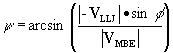
The movement of convective systems is composed of the sum of an advective component, given by the mean motion of the convective cells, and a propagation component, defined by the rate and location of new convective cell formation relative to existing cells (Newton and Katz 1958, Newton and Newton 1959, Bluestein and Jain 1985). Merritt and Fritsch (1984) and Corfidi et al. (1996) applied this concept to the movement of the heavy-rain-producing meso-b scale elements (MBEs) of mesoscale convective complexes. They examined 103 MCSs (of which 99 satisfied the criteria for an MCC) and found, as did the early radar studies of Brooks (1946) and Byers and Braham (1949), that individual cells within MCSs tended to be swept downwind with the mean flow in the cloud layer (VCL). However, the MBEs tended to move at roughly half the speed of the supporting meso-a scale system (McAnnelly and Cotton 1986, 1989) and often departed significantly from the direction of the mean flow. Corfidi et al. (1996) defined the departure of the observed movement of the MBEs (VMBE) from the mean cloud-layer flow as the propagation component (VPROP) of the MBEs ( Fig. 24 ). Further examination of the 103 MCSs revealed that VPROP tended to be directed opposite to the low-level flow supplying the system with high-qe air. Usually this inflow was dominated by a low-level jet (VLLJ). Thus, using these relationships, they constructed a simple model for predicting the movement of the heavy rain areas of MCSs. This model is presented in Fig. 24 and is mathematically expressed as
VMBE = VCL - VLLJ . (5)
Following Fankhauser (1964), they calculated the mean flow in the cloud layer from
![]() , (6)
, (6)
where the direction and magnitude of the wind at each level on the right hand side is taken to be representative of the 900-800 mb, 800-600 mb, 600-400 mb and 400-200 mb layers, respectively. Estimates of the speed and direction of the low level jet are obtained following the criteria of Bonner (1968). Only wind maxima at or below 1.5 km above ground level are considered low-level jets since the thunderstorm cells of developing systems are most likely to ingest air from near the surface.
Once estimates for VCL and VLLJ are in hand, the magnitude of VMBE is determined using the following simple geometric relationship
![]() , (7)
, (7)
where f is the angle between the mean cloud-layer wind and the low-level jet (see Fig. 24 ). Similarly, MBE direction can be determined using an elementary relationship for the angle y between the direction of MBE movement and the mean cloud-layer wind:
 , (8)
, (8)
where MBE speed is given by (7). Corfidi et al. (1996) used soundings taken during the initiation and development phases of the systems to test the conceptual model. Their results, shown in Fig. 25 , indicate considerable skill in forecasting MBE movement. For example, they calculated that, for the typical MCC in the U.S., the average error in the location of the center of the MBE activity at the time the system dissipates would be about 100-150 km. Moreover, for most of the system's life cycle, the typical location error would be less than 100 km, which is well within the approximately 300-km width of the heavy rain ( 13 mm) area of most MCCs (see Fig. 9 ).
Chappell (1986) used the same conceptual model proposed by Merritt and Fritsch (1984) to argue that certain configurations of the environmental flow favor the occurrence of very heavy rains and flash floods. In particular, he recognized from their model that when the low-level jet is similar in magnitude and direction to the mean flow in the cloud layer, the propagation component of the MBEs will be directed opposite to the movement of individual cells. Thus, systems will tend to remain nearly stationary or even propagate upstream (backbuild), especially if the low-level jet is stronger than the mean flow in the cloud layer ( Fig. 24 ). Shi and Scofield (1987) further refined Merritt and Fritsch's conceptual model for backbuilding systems by introducing the configuration of the thermodynamic fields ( Fig. 26 ). Specifically, they examined nine backward-propagating MCSs and found that eight of them propagated along and north of the axis of the maximum mean value of qe in the cloud layer (850-300 mb). Since the deep-tropospheric axis of maximum qe is likely dominated by the highest qe values at low levels, their results simply infer that the MCSs tend to propagate toward the highest qe air feeding the convective updrafts. It is well known that situations with slow moving, quasi-stationary or backbuilding systems where individual cells form and 'train' over the same region are a favored mechanism for the production of locally heavy rainfall (Simpson and Woodley 1971; Maddox et al. 1979; Chappell 1986; Shi and Scofield 1987).
6. Modification of the Regional Environment
As noted in section 1, MCCs are sufficiently large and long-lived that the earth's rotation becomes a factor in determining their dynamical structure and circulation. As such, their structure and circulation should tend to follow the balanced dynamical constraints derivable from potential vorticity concepts. According to Haynes and McIntyre (1987), the mass-integrated potential vorticity in a layer between two isentropic surfaces remains constant even if mass is transported in or out of the layer. Therefore, removal (addition) of mass from (to) a layer will necessitate an increase (decrease) in the potential vorticity. Raymond and Jiang (1990) recognized this relationship and noted that moist convection transports mass across isentropic surfaces from low levels to high levels. Thus, they reasoned that the massive moist convective transports by MCSs should have a profound effect on their large scale environment and result in a low-level positive potential vorticity anomaly with a negative potential vorticity anomaly above. This notion can be refined somewhat by recognizing that much of the air that ascends moist adibatically to high levels in MCCs originates not just from the low-level surface-based mixed layer but from a thick mid-level layer typically extending from the surface-based mixed layer to approximately 6 km above ground level (eg., see Ogura and Liou 1980, Smull and Houze 1985, 1986, Rotunno et al. 1988, Smull and Augustine 1993). Moreover, there is also a substantial moist adiabatic transport of mass from mid-levels to low-levels by the cloud and mesoscale moist downdrafts (eg., Smull and Houze 1987, Fovell and Ogura 1988, Johnson and Hamilton 1988, Johnson et al. 1989, Zhang et al. 1989, Brandes and Ziegler 1993). Thus, the origination layer for most air parcels that participate in moist overturning in MCSs can be most accurately characterized as coming more from mid-levels (considered here to be the layer between 2 and 6 km) than from low-levels. Correspondingly, high levels where moist updrafts detrain would be predominantly mass deposition layers. Low levels act as both a source (for updrafts) and as a sink (for downdrafts). Therefore, according to Raymond and Jiang's reasoning, a negative potential vorticity anomaly should develop at high levels and a positive anomaly, underlain by relatively cold air, should form at mid-levels.
In agreement with these potential vorticity theory arguments, many studies (eg., Houze 1989, Cotton et al. 1989) have shown that the characteristic vertical heating profile with MCSs tends to cool the atmosphere near tropopause levels, warm the upper troposphere, and cool the lower troposphere. This form of heating profile favors vertical changes in stability that support development of a positive potential vorticity anomaly at mid-levels and a negative anomaly at high levels. Still further, calculations of the vertical distribution of divergence in MCSs show pronounced convergence at mid-levels and strong divergence near the tropopause and in the lower troposphere (Maddox 1983, Cotton et al. 1989, Johnson and Bartels 1992, Smull and Augustine 1993). From the stretching term of the baroclinic vorticity equation, this distribution of divergence implies vorticity spin up at mid-levels and spin down at high levels. Therefore, both stability and vorticity tendencies work in favor of generating a positive potential vorticity anomaly at mid-levels and a negative anomaly at high levels.
An overwhelming body of observational evidence indicates that mesoscale convective systems, especially MCCs, generate environmental changes that strongly agree with the potential vorticity concepts outlined above. Cross sections through MCCs ( Fig. 27 ; Wetzel et al. 1983) clearly show a warm upper troposphere with cold layers above and below. Correspondingly, it is well known that MCSs frequently exhibit a low-level cold pool and meso-high (eg., Bosart and Sanders 1981, Menard and Fritsch 1989, Brandes 1990, Johnson and Bartels 1992, Fritsch et al. 1994, Loehrer and Johnson 1995). Similarly, numerous investigators have documented the development of a pronounced anticyclone with an attendant cold dome near tropopause levels (eg., Fig. 28 ; see Leary and Thompson 1976, Houze 1977, Leary 1979, Gamache and Houze 1982, Fritsch and Maddox 1981, Maddox 1983, Wetzel et al. 1983, Velasco and Fritsch 1987, Zhang and Fritsch 1988b, Cotton et al. 1989). And, as expected, potential vorticity analyses of MCS events exhibit a mid-level maximum and a high-level minimum (eg., Fig. 29 ; Fritsch et al. 1994; Bartels et al. 1997).
Of most interest has been the formation of long-lived mid-level meso-vortices, a reflection of MCS-created mid-level positive potential vorticity anomalies. These warm-core mesoscale cyclonic circulations were first noticed with tropical MCSs (Leary and Thompson 1976, Houze 1977, Leary 1979, Gamache and Houze 1982, 1985, Houze and Rappaport 1984) and are often seen in the cloud debris of MCCs (eg., Fig. 30 ; Menard and Fritsch 1989, Bartels and Maddox 1991, Johnson and Bartels 1992, Bartels et al. 1997). The development of such vortices is thought to be an inherent process characteristic of MCCs (Velasco and Fritsch 1987, Menard and Fritsch 1989, King 1996). Their significance to severe weather stems from their ability to induce subsequent cycles of deep moist convective overturning (Raymond and Jiang 1990, Fritsch et al. 1994, Davis and Weisman 1994) that sometimes produces extreme rainfall (eg., 300 mm: Bosart and Sanders 1981; 250 mm: Fritsch et al. 1994; 700 mm: Caracena and Fritsch 1983). It is also of interest that their dynamical structure and circulation resemble that of tropical disturbances and that maritime MCCs have developed into tropical storms and hurricanes (Velasco and Fritsch 1987, Miller and Fritsch 1991).
Raymond and Jiang (1990) and Davis and Weisman (1994) demonstrated that the upward motion thought necessary for convective redeveloment within a mid-level mesovortex can only occur in the presence of ambient vertical shear. As theorized by Raymond (1992) and as observed by Fritsch et al (1994), the vertical motion arises primarily from the differential movement of air (relative to the vortex ) along the sloping isentropic surfaces associated with the vortex ( Fig. 29 ). Davis and Weisman (1994) and Skamarock et al. (1994), who provide an excellent discussion of the balanced dynamics of convectively-generated mesovortices and squall lines, simulated the interaction of an idealized mesovortex with various configurations of environmental vertical shear. They found that weak shear confined to low-levels provides an optimal environment for maintaining the vortex while still providing an opportunity for convective redevelopment. This is precisely the type of environment within which the long-lived convectively-generated mesovortex documented by Fritsch et al. (1994) formed, underwent five convective redevelopments, tripled its detectable size, and survived for three days as it traveled from Colorado to Quebec.
In addition to their tendency to develop balanced mid-level meso-vortices, MCCs also produce many other effects on their near environment. For example, Webster and Stephens (1980) presented evidence that the large and deep cloud layer with organized convective systems acts to absorb and reradiate outgoing long-wave radiation thereby resulting in local nocturnal warming of the lower troposphere. Conversely, Maddox and Heckman (1982) used ten MCC events to document how MCCs severely reduce incoming shortwave radiation and alter the sensible and latent heat fluxes at the surface. In particular, they used the errors in Model Output Statistics (MOS) daytime maximum temperature forecasts (Klein and Hammons 1975, Carter et. al. 1979) as an objective measure of how the afternoon high temperatures were reduced by the cloudiness, wet ground, and moist downdrafts from the ten MCCs. Figure 31 presents an example of the MOS temperature errors (observed temperatures minus the MOS forecast values) for a typical event. Diabatically-forced low-level cooling over this great an area and of this magnitude can shift the location of lower-tropospheric baroclinic zones and can thereby alter the phase/height relationship of traveling baroclinic disturbances. Zhang and Harvey (1995) showed that such a shift occurred with the PRE-STORM June 10-11 convective system and upper-level short wave and was instrumental in significantly deepening and changing the location of the surface cyclone associated with the upper-level traveling disturbance.
Along with the modifications to their near environment, MCSs also strongly alter their large-scale environment. For example, Stensrud (1996) estimated the effect of multiple MCSs on the large scale by computing the difference between numerical model simulations of a 4-day period that included 15 MCSs over the central U. S. and an identical simulation except that the diabatic effects of the convective systems were omitted. His results show that the cumulative effects of the MCSs have a profound effect on the synoptic scale. A truly massive anticyclonic perturbation is imposed near tropopause levels ( Fig. 32a ) and a correspondingly large cyclonic perturbation is introduced at low levels ( Fig. 32b ). These changes strongly resemble the more local changes caused by individual large convective systems. Stensrud also showed that the convective systems produce a positive feedback such that the large scale environment is more favorable for additional convection, a result that would tend to extend the lifetime of the convective activity and the potential for severe weather in the same region.
7. Summary
Mesoscale convective systems are globally ubiquitous and play a key role in the earth's hydrologic cycle. In the U.S. and many other areas of the world, they produce copious rainfall and a significant fraction of the reports of heavy rain, flash floods and severe weather.
Typically, these systems undergo a lifecycle that commences with the appearance of individual thunderstorms during the late afternoon or evening and then evolves into a complex structure of stratiform clouds, precipitation and embedded areas of moist convection. A typical system produces a cold cloud shield that covers hundreds of thousands of square km and persists for six or more hours. The largest systems, mesoscale convective complexes, are predominantly nocturnal, producing their peak cold cloud shields shortly after midnight local time. Severe weather occurs most commonly during the early portion of their lifecycle in conjunction with intense individual thunderstorms. Heavy rains and flash flooding tend to occur later as mesoscale circulations develop and the environment moistens.
The large scale environment and forcing mechanisms for producing MCSs vary greatly. However, for the very large long-lived systems (MCCs), there appear to be two kinds of environments that characterize most events. In what we term type-1 events, the convective mass flux emanates from an elevated layer overrunning the cool side of a surface-based front or baroclinic zone. Type-2 events form in more barotropic environments wherein the convective mass flux emanates from a surface-based well-mixed layer. In type-2 events, the convection itself, through the action of moist downdrafts, creates a mechanism for subsequent lifting and organization of the convective overturning. Significantly, a key feature common to both types of events is that the MCS structure and characteristics do not develop unless a broad and deep layer of conditionally unstable air is brought to saturation. In type-1 events, slantwise overrunning forced by large scale baroclinic features facilitates the layer lifting. In type-2 events, the layer- lifting mechanism is sensitive to the relative strengths of vertical wind shear and the moist-downdraft-generated cold pool. Other environmental features common to most significant events are low-level jets, weak mid-level short waves, and pronounced lower-tropospheric warm advection. One of the factors that distinguishes most MCC population centers from other regions of convective activity is that these favored areas have a mechanism (the terrain/radiation forced low-level jet) that can transport low-level warm moist air much faster and farther than what would occur due to quasi-geostrophic forcing from traveling disturbances and synoptic features alone. This results in greater CAPE, thereby enhancing the size and strength of the thunderstorms that comprise the convective systems.
Virtually all MCSs are composed of deep convective elements and an associated region of stratiform clouds and precipitation. The convective elements have a tendency to be organized into lines although many systems, especially in large type-1 events, display more-or-less random distributions of the convective structures. As expected, the convective portions of the systems produce the bulk of the severe weather and flash flooding. Stratiform regions typically display lighter rainfall with mesoscale ascent in the upper troposphere and descent below. The ascending branch of the circulation is anomalously warm relative to the larger scale environment whereas the descending branch, chilled by melting and evaporation, is characteristically cool. At mid-levels, the stratiform region frequently exhibits pronounced convergence and cyclonically spiralling bands.
As with individual thunderstorms, the movement of most MCSs is the result of the combined contributions of advection and propagation. This is especially true of the intense convective rain areas responsible for the bulk of the severe weather and flooding. The advective component correlates strongly with the mean flow in the cloud layer. The departure from the mean cloud-layer flow is strongly influenced by the speed and direction of the low-level inflow of high qe air feeding the deep convective overturning. New growth favors this inflow area and the systems therefore tend to propagate toward the source of the high qe air, i.e., in a direction opposite the low-level inflow. It has been shown that a reasonable estimate of the speed and direction of MCSs can be obtained from the vector difference between the mean flow in the cloud layer and the low-level jet.
More recent studies have shown that the tendency for MCSs to propagate toward the source of the high qe air feeding the convection (usually southward in the U.S.) is augmented or possibly even dominated by the interaction of the MCS-generated cold pool with Coriolis accelerations. Specifically, Skamarock et al. (1994) found that, relative to numerical simulations of squall lines without Coriolis effects, the with-Coriolis simulations showed greater anticyclonic turning of the gust front winds. This leads to enhanced convergence and deeper lifting along the right (left) flank of northern (southern) hemisphere convective lines. Additional convection as a result of the enhanced forcing re-enforced the cold outflow thereby promoting a further rightward (leftward) advancement of a northern (southern) hemisphere line. Conceivably, the conceptual model presented in Section 5 could be modified or enhanced by introducing a measure of cold pool strength, especially for forecasting the movement of warm sector squall lines.
Finally, there is a wealth of evidence that shows that MCSs substantially alter their large scale environment. The most commonly observed changes show that the systems generate a positive potential vorticity anomaly at mid-levels and a negative anomaly near the tropopause. These features are balanced structures and have been observed to persist for several days. They are typically manifested as a mid-level mesovortex, a high-level anticyclone, and a surface-based cold pool and mesohigh. Under certain conditions, the positive potential vorticity anomaly can be instrumental in initiating new MCSs, sometimes with devastating consequences in the form of very heavy rainfall and flash floods.
Acknowledgments
The authors gratefully acknowledge the contributions of Bill Frank, Peter Bannon, John Clark, Jack Kain, Rob Rogers, and Craig Bishop. We are especially grateful to George Bryan for providing several of the Doppler radar figures.
REFERENCES
Augustine, J. A. and F. Caracena, 1994: Lower-tropospheric precursors to nocturnal MCS development over the Central United States. Wea. Forecasting., 9, 116-135.
Augustine, J. A. and K. W. Howard, 1988: Mesoscale convective complexes over the United States during 1985. Mon. Wea. Rev., 116, 685-701.
Augustine, J. A. and K. W. Howard, 1991: Mesoscale convective complexes over the United States during 1986 and 1987. Mon. Wea. Rev., 119, 1575-1589.
Augustine, J. A. and E. J. Zipser, 1987: The use of wind profilers in a mesoscale experiment. Bull. Amer. Meteor. Soc., 68, 4-17.
Bartels, D. L. and R. A. Maddox, 1991: Midlevel cyclonic vortices generated by mesoscale convective systems. Mon. Wea. Rev., 119, 104-118.
Bartels, D. L., J. M. Brown and E. I. Tollerud,1997: Structure of a midtropospheric vortex induced by a mesoscale convective system. Mon. Wea. Rev., 125, 193-211.
Blackadar, A.K., 1957: Boundary layer wind maxima and their significance for the growth of nocturnal inversions. Bull. Amer. Meteor. Soc., 38, 283-290.
Bleeker, S. and M. J. Andre, 1951: On the diurnal variation of precipitation, particularly over central U.S.A. and its relation to large-scale orographic circulation systems. Q. J. Roy. Meteor. Soc., 77, 260-271.
Bluestein, H. B. and M. H. Jain, 1985: Formation of mesoscale lines of precipitation: Severe squall lines in Oklahoma during the spring. J. Atmos. Sci., 42, 1711-1732.
Bluestein, H. B., G. T. Marx and M. H. Jain 1987: Formation of mesoscale lines of precipitation: Nonsevere squall lines in Oklahoma during the spring. Mon. Wea. Rev., 115, 2719-2727.
Bonner, W. D., 1968: Climatology of the low level jet. Mon. Wea. Rev., 96, 833-850.
Bosart, L. F. and F. Sanders, 1981: The Johnstown flood of July 1977: A long-lived convective storm. J. Atmos. Sci., 38, 1616-1642.
Brandes, E. A., 1990: Evolution and structure of the 6-7 May 1985 mesoscale convective system and associated vortex. Mon. Wea. Rev., 118, 109-127.
Brandes, E. A. and C. L. Ziegler, 1993: Mesoscale downdraft influences on vertical vorticity in a mature mesoscale convective system. Mon. Wea. Rev., 121, 1337-1353.
Brooks, H. B., 1946: A summary of some radar thunderstorm observations. Bull. Amer. Meteor. Soc., 27, 557-563.
Brunk, I. W., 1953: Squall lines. Bull. Amer. Meteor. Soc., 34, 1-9.
Burpee, R. W., 1979: Peninsular-scale convergence in the south Florida seabreeze. Mon. Wea. Rev., 107, 852-860.
Byers, H. R. and R. R. Braham, Jr., 1949: The Thunderstorm. U. S. Government Printing Office, 287 pp.
Caracena, F. and J. M. Fritsch, 1983: Focusing mechanisms in the Texas Hill Country Flash floods of 1978. Mon. Wea. Rev., 111, 2319-2332.
Carter, G. M., J. P. Dallavalle, A. L. Forst, and W. H. Klein, 1979: Improved automated surface temperature guidance. Mon. Wea. Rev., 107, 1263-1274.
Chappell, C. F., 1986: Quasi-stationary convective events. Mesoscale Meteorology and Forecasting (Peter Ray, Ed.), American Meteorological Society, Boston, 289-310.
Chen, S. and W. R. Cotton, 1988: The sensitivity of a simulated extratropical mesoscale convective system to longwave radiation and ice-phase microphysics. J. Atmos. Sci., 45, 3897-3910.
Chen, S. S. and W. M. Frank, 1993: A numerical study of the genesis of extratropical convective mesovortices. Part I: Evolution and dynamics. J. Atmos. Sci., 50, 2401-2426.
Chong, M., P. Amayenc, G. Scialom and J. Testud, 1987: A tropical squall line observed during the COPT 81 Experiment in West Africa. Part I: Kinematic structure inferred from dual-doppler radar data. Mon. Wea. Rev., 115, 670-694.
Colby, F. P., Jr., 1984: Convective inhibition as a predictor of convection during AVE-SESAME II. Mon. Wea. Rev., 112, 2239-2252.
Collander, R. S., 1993: A ten-year summary of severe weather in mesoscale convective complexes, Part 2: Heavy rainfall. Preprints, 17th Conference on Severe Local Storms, 4-8 October, St. Louis, MO, American Meteorological Society, 638-641.
Cooper, H. J., M. Garstang and J. Simpson, 1982: The diurnal interaction between convection and peninsular-scale forcing over south Florida. Mon. Wea. Rev., 110, 486-503.
Corfidi, S. F., J. H. Merritt and J. M. Fritsch, 1996: Predicting the movement of mesoscale convective complexes. Wea. Forecasting, 11, 41-46.
Cotton, W. R., M.-S. Lin, R. L. McAnelly and C. J. Tremback, 1989: A composite model of mesoscale convective complexes. Mon. Wea. Rev., 117, 765-783.
Cotton, W.R. and R.L. McAnelly, 1992: Early growth of mesoscale convective complexes: A meso- -scale cycle of convective precipitation? Mon. Wea. Rev.,120, 1851-1877.
Cunning, J., 1986: The Oklahoma-Kansas preliminary regional experiment for STORM-Central. Bull. Amer. Meteor. Soc., 67, 1478-1486.
Davis, C. A. and M. L. Weisman, 1994: Balanced dynamics of mesoscale vortices produced in simulated convective systems. J. Atmos. Sci., 51, 2005-2030.
Devlin, K. I., 1995: Application of the 85Ghz ice scattering signature to a global study of mesoscale convective systems. M.S. thesis, Texas A&M University, 99pp.
Dopplick, T. G., 1972: Radiative heating of the global atmosphere. J. Atmos. Sci., 29, 1278-1294.
Fankhauser, J. C., 1964: On the motion and predictability of convective systems. National Severe Storms Prediction Center, Rep. 21, 34 pp.
Fortune, M. A., W. R. Cotton and R. L., McAnelly, 1992: Frontal-wave-like evolution in some mesoscale convective complexes. Mon Wea. Rev., 120, 1279-1300.
Foster, D.S., 1958: Thunderstorm gusts compared with computed downdraft speeds. Mon. Wea. Rev., 86, 91-94.
Fovell, R. G. and Y. Ogura, 1988: Numerical simulation of a squall line in two dimensions. J. Atmos. Sci., 45, 3846-3879.
Fovell, R. G. and Y. Ogura, 1989: Effect of vertical wind shear on numerically simulated multicell storm structure. J. Atmos. Sci., 46, 3144-3176.
Fritsch, J. M., R.A. Maddox, and A. G. Barnston, 1981: The character of mesoscale convective complex precipitation and its contribution to the warm season rainfall in the U.S. Preprints, Fourth Conf. on Hydrometeorology, Oct. 7-9, Reno, Nevada, American Meteorological Society, 94-99.
Fritsch, J. M. and R. A. Maddox, 1981: Convectively-driven mesoscale pressure systems aloft, Part I: Observations. J. Clim. Appl. Meteor., 20, 9-19.
Fritsch, J. M., R. J. Kane and C. H. Chelius, 1986: The contribution of mesoscale convective weather systems to the warm season precipitation in the United States. J. Clim. and Appl. Meteo., 25, 1333-1345.
Fritsch, J. M., J. D. Murphy and J. S. Kain, 1994: Warm core vortex amplification over land. J. Atmos. Sci., 51, 1781-1806.
Fujita, T., 1955: Results of detailed synoptic studies of squall lines. Tellus, 4, 405-436.
Gamache, J. F. and R. A. Houze, 1982: Mesoscale air motions associated with a tropical squall line. Mon. Wea. Rev., 110, 118-135.
Gamache, J. F. and R. A. Houze, 1985: Further analysis of the composite wind and thermodynamic structure of the 12 September GATE squall line. Mon. Wea. Rev., 113, 1241-1259.
Garstang, M., H. L. Massie Jr., J. Halverson, S. Greco, J. Scala, 1994: Amazon Coastal squall lines. Part 1: Structure and Kinematics. Mon. Wea. Rev., 122, 608-622.
Geldmeier, M. F. and G. M. Barnes, 1997: The "footprint" under a decaying tropical mesoscale convective system. Mon. Wea. Rev., 125, 2879-2895.
Gray, W. M., 1979: Hurricanes: Their formation, structure and likely role in the tropical circulation. Supplement to Meteorology over the Tropical Oceans. James Glaisher House, Grenville Place, Bracknell, Berkshire, RG 12 1BX, D. B. Show, ed., 155-218.
Gray, W. M. and R. W. Jacobson, 1977: Diurnal variation of deep convective system in the Tropics. Mon. Wea. Rev., 105, 1171-1188.
Greco, S., R. Swap, M. Garstang, S. Ulanski, M. Shipman, R. C. Harris, R. Talbot, M. O. Andrae and P. Artaxo, 1992: Rainfall and surface kinematic conditions over Central Amazonia during ABLE 2B. J. Geophys. Res., 95, 17,001-17,014.
Hane, C. E., 1986: Extratropical squall lines and rainbands. Mesoscale Meteorology and Forecasting (Peter Ray, Ed.), American Meteorological Society, Boston, 359-389.
Haynes, P. H. and M. E. McIntyre, 1987: On the evoluton of vorticity and potential vorticity in the presence of diabatic heating and frictional or other forces. J. Atmos. Sci., 44, 828-841.
Holton, J. R., 1967: The diurnal boundary layer wind oscillation above sloping terrain. Tellus, 19, 199-205.
Houze, R. A., 1977: Structure and dynamics of a tropical squall-line system. Mon. Wea. Rev., 105, 1540-1567.
Houze, R. A., 1989: Observed structure of mesoscale convective systems and implications for large scale heating. Q. J. R. Meteorol. Soc., 115, 425-461.
Houze, R. A. and E. N. Rappaport, 1984: Air motions and precipitation structure of an early summer squall line over the eastern tropical Atlantic. J. Atmos. Sci., 41, 553-574.
Houze, R. A., Jr., S.A. Rutledge, M. I. Biggerstaff and B. F. Smull, 1989: Interpretation of Doppler weather radar displays of midlatitude mesoscale convective systems. Bull. Amer. Meteor. Soc., 70, 608-619.
Houze, R. A., B. F. Smull and P. Dodge, 1990: Mesoscale organization of springtime rainstorms in Oklahoma. Mon. Wea. Rev., 118, 613-654.
Johns, R. H., 1993: Meteorological conditions associated with bow echo development in convective storms. Wea. Forecasting, 8, 294-299.
Johns, R. H. and W. D. Hirt, 1987: Derchos: widespread convectively induced windstorms. Wea. Forecasting, 2, 32-49.
Johnson, R. H. and D. L. Bartels, 1992: Circulations associated with a nature-to-decaying mid-latitude mesoscale convective system. Part II: Upper-level features. Mon. Wea. Rev., 120, 1301-1320.
Johnson, R. H. and P. J. Hamilton, 1988: The relationship of suface pressure features to the precipitation and air flow structure of an intense midlatitude squall line. Mon. Wea. Rev., 116, 1444-1472.
Johnson, R. H., S. Chen and J. J. Toth, 1989: Circulations associated with a mature-to-decaying midlatitude mesoscale convective system. Part I: Surface features - - - Heat bursts and mesolow development. Mon. Wea. Rev., 117, 942-959.
Kain, J. S. and J. M. Fritsch, 1998: Multiscale convective overturning in mesoscale convective systems: Reconciling observations, simulations and theory. Mon. Wea. Rev., 126, 2254-2273.
Kane, R. J., C. R. Chelius and J. M. Fritsch, 1987: The precipitation characteristics of mesoscale convective weather systems. J. Clim. and Appl. Meteor., 26, 1323-1335.
Keenan, T. D. and R. E. Carbone, 1992: A preliminary morphology of precipitation systems in tropical northern Australia. Q. J. R. Meteorol. Soc., 118, 283-326.
King, R. G., 1996: Mid-level vorticity in mesoscale convective systems. Atmospheric Science Paper No. 606, Department of Atmospheric Science, Colorado State University, 92 pp.
Klein, W. H. and G. A. Hammons, 1975: Maximum/minimum temperature forecasts based on model output statistics. Mon. Wea. Rev., 103, 796-806.
Klemp, J. B., 1987: Dynamics of tornadic thunderstorms. Ann. Rev. Fluid Mech., 19, 369-402.
Knupp, K. R., 1987: Downdrafts within High Plains cumulonimbi. Part 1: General kinematic structure. J. Atmos. Sci, 44, 987-1008.
Knupp, K. R. and W. R. Cotton, 1985: Precipitating convective cloud downdraft structure: An interpretive survey. Rev. Geophys., 23, 183-215.
Kousky, V.E., 1980: Diurnal rainfall variation in northeastern Brazil. Mon. Wea. Rev., 108, 488-498.
Laing, A. G., 1992: Mesoscale convective complexes over Africa and the Indian subcontinent. M. S. thesis, The Pennsylvania State University. (Available from the Dept. of Meteorology, 503 Walker Building, Pennsylvania State University, University Park, PA 16802, USA)
Laing, A. G., 1996: A global climatology of mesoscale convective complexes. Doctoral dissertation, The Pennsylvania State University, 158 pp.
Laing, A. G. and J. M. Fritsch, 1993a: Mesoscale convective complexes over the Indian monsoon region. J. Climate, 6, 911-919 .
Laing, A. G. and J. M. Fritsch, 1993b: Mesoscale convective complexes in Africa. Mon. Wea. Rev., 121, 2254-63.
Laing, A. G. and J. M. Fritsch, 1997: The global population of mesoscale convective complexes. Q. J. Roy. Meteor. Soc., 123, 389-405.
Laing, A. G. and J. M. Fritsch, 1999: The large scale environments of the global populations of mesoscale convective complexes. Accepted by Mon. Wea. Rev.
Laurent, H., 1996: Tracking of convective cloud clusters from Meteosat data. Tenth Meteosat Scientific Users' Conference, Cascais, Portugal, 5-9 September, page numbers.
Leary, C. A., 1979: Behavior of the wind field in the vicinity of a cloud cluster in the intertropical convergence zone. J. Atmos. Sci., 36, 631-639.
Leary, C. A. and E. N. Rappaport, 1987: The life cycle and internal structure of a mesoscale convective complex. Mon. Wea. Rev., 115, 1503-1527.
Leary, C. A. and R. O. Thompson, 1976: A warm-core disturbance in the Western Atlantic during BOMEX. Mon. Wea. Rev., 104, 443-452.
Lilly, D. K. and T. Gal-Chen, 1983: Mesoscale meteorology: Theories, observations and models. NATO Advanced Science Institute Series, D. Reidel, 781 pp.
Loehrer, S. M. and R. H. Johnson, 1995: Surface pressure and precipitation life cycle characteristics of PRE-STORM mesoscale convective systems. Mon. Wea. Rev., 123, 600-621.
Machado, L. A. T., and W. B. Rossow, 1993: Structural characteristics and radiative properties of tropical cloud clusters. Mon. Wea. Rev., 121, 3234-3260.
Maddox, R. A., 1980: Mesoscale convective complexes. Bull. Amer. Meteor. Soc.. 61, 1374-1387.
Maddox, R. A., 1983: Large-scale meteorological conditions associated with mid-latitude, mesoscale convective complexes. Mon. Wea. Rev., 111, 1475-1493.
Maddox, R. A., C. F. Chappell and L. R. Hoxit, 1979: Synoptic and meso-a-scal
e aspects of flash flood events. Bull. Amer. Meteor. Soc., 60, 115-123.
Maddox, R. A. and B. E. Heckman, 1982: The impact of mesoscale convective weather systems upon MOS temperature guidance. Preprints, 9th Conference on Weather Forecasting and Analysis, 28 June-1 July, Seattle, WA, Amer. Meteor. Soc., Boston, 214218.
Maddox, R. A., K. W. Howard, D. L. Bartels and D. M. Rodgers, 1986: Mesoscale convective complexes in the middle latitudes. Mesoscale Meteorology and Forecasting (Peter Ray, Ed.), American Meteorological Society, Boston, 390-413.
Mapes, B., 1993: Gregarious tropical convection. J. Atmos. Sci., 50, 2026-2037.
Mapes, B. and R. A. Houze, 1992: An integrated view of the 1987 Australian monsoon and its mesoscale convective systems. I: Horizontal structure. Q. J. R. Meteorol. Soc., 118, 927-963.
McAnelly, R. L. and W. R. Cotton, 1986: Meso-b-scale characteristics of an episode of meso-a-scale convective complexes. Mon. Wea. Rev., 114, 1740-1770.
McAnelly, R. L. and W. R. Cotton, 1989: The precipitation life cycle of mesoscale convective complexes over the central United States. Mon. Wea. Rev., 117, 784-808.
McNider, R. T. and R. A. Pielke, 1981: Diurnal boundary-layer development over sloping terrain. J. Atmos. Sci., 38, 2198-2212.
Menard, R. D. and J. M. Fritsch, 1989: An MCC-generated inertially stable warm core vortex. Mon. Wea. Rev., 117, 1237-1260.
Merritt, J. H., 1985: The synoptic environment and movement of mesoscale convective complexes over the United States. Master's thesis, The Pennsylvania State University, 129 pp.
Merritt, J. H. and J. M. Fritsch, 1984: On the movement of the heavy precipitation areas of mid-latitude mesoscale convective complexes. Preprints, 10th Conference on Weather Forecasting and Analysis, June 25-29, Tampa, FL, Amer. Meteor. Soc., Boston, 529-536.
Miller, D., 1990: Mesoscale convective complexes in the western Pacific region. M. S. thesis, The Pennsylvania State University. (Available from the Dept. of Meteorology, 503 Walker Building, Pennsylvania State University, University Park, PA 16802, USA)
Miller, D. and J. M. Fritsch, 1991: Mesoscale convective complexes in the western Pacific region. Mon. Wea. Rev., 119, 2978-2992.
Newton, C. W., 1950: Structure and mechanism of the prefrontal squall line. J. Meteor., 7, 210-222.
Newton, C. W. and S. Katz, 1958: Movement of large convective rainstorms in relation to winds aloft. Bull. Amer. Meteor. Soc., 39, 129-136.
Newton, C. W. and H. R. Newton, 1959: Dynamical interactions between large convective clouds and environment with vertical shear. J. Meteor., 16, 483-496.
Nicolini, M., K. M. Waldron and J. Paegle, 1993: Diurnal oscillation of low-level jets, vertical motion, and precipitation: A model case study. Mon. Wea. Rev., 121, 2588-2610.
Ogura, Y. and Y.-L. Chen, 1977: A life history of an intense mesoscale convective storm in Oklahoma. J. Atmos. Sci., 34, 1458-1476.
Ogura, Y. and M.-T. Liou, 1980: The structure of a midlatitude squall line: A case study. J. Atmos. Sci., 37, 553-567.
Pandya, R. E. and D. R. Durran, 1996: The influence of convectively generated thermal forcing on the mesoscale circulation around squall lines. J. Atmos. Sci., 53, 2924-2951.
Paegle, J., 1978: The transient mass-flow adjustment to heated atmospheric circulations. J. Atmos. Sci., 35, 1678-1688.
Pedgley, D. E., 1962: A meso-synoptic analysis of the thunderstorms on 28 August 1958. Geophys. Mem. 106, Meteorological Office 711, 74 pp (Available from Her Majesty's Stationery Office, London, England).
Purdom, J. F. W., 1976: Some uses of high-resoluton GOES imagery in the mesoscale forecasting of convection and its behavior. Mon. Wea. Rev., 104,1474-1483.
Raymond, D.J. and H. Jiang, 1990: A theory for long-lived mesoscale convective systems. J. Atmos. Sci., 47, 3067-3077.
Rochette, S. M. and J. T. Moore, 1996: Initiation of an elevated mesoscale convective system associated with heavy rainfall. Wea. and Forecasting, 11, 443-457.
Rose, M. A., 1996: Downbursts. Nat. Wea. Dig., 21, 11-17.
Rotunno, R. and J. B. Klemp, 1985: On the rotation and propagation of simulated supercell thunderstorms. J. Atmos. Sci., 42, 271-292.
Rotunno, R., J. B. Klemp and M. L. Weisman, 1988: A theory for strong, long-lived squall lines. J. Atmos. Sci., 45, 463-485.
Sanders, F. and J. R. Gyakum, 1980: Synoptic-dynamic climatology of the "Bomb". Mon. Wea. Rev., 108, 1589-1606.
Sawyer, J. S., 1956: The vertical circulation at meteorological fronts and its relation to frontogenesis. Proc. Roy. Soc. London, A234, 346-362.
Schmidt, J. M. and W. R. Cotton, 1989: A high plains squall line associated with severe surface winds. J. Atmos. Sci., 46, 281-302.
Schmidt, J. M. and W. R. Cotton, 1990: Interactions between upper and lower tropospheric gravity waves on squall line structure and maintenance. J. Atmos. Sci., 47, 1205-1222.
Schubert, W. H., J. J. Hack, P. L. Silva Dias and S. R. Fulton, 1980: Geostrophic adjustment in an axisymmetric vortex. J. Atmos. Sci., 37, 1464-1484.
Scofield, R.A. and L. Naimeng, 1994: The use of satellite imagery during the great floods of 1993. Preprints, Seventh Conference on Satellite meteorology and Oceangraphy, June 6-10 Monterey, CA, American Meteorological Society, 345-350.
Shi, J. and R. A. Scofield, 1987: Satellite-observed mesoscale convective system (MCS) propagation characterictics and a 3-12 hour heavy precipitation forecast index. NOAA Tech. Memo NESDIS 20, U.S. Dept. of Commerce, Washington, D.C., 43 pp.
Simpson, J. and W. L. Woodley, 1971: Seeding cumulus in Florida: New 1970 results. Science, 172, 117-126.
Simpson, J., N. E. Wescott, R. J. Clerman and R. A. Pielke, 1980: On cumulus mergers. Arch. Meteor. Geophys. Bioklim., A29, 1-40
Simpson, J., Th. D. Keenan, B. Ferrier, R. H. Simpson and G. J. Holland, 1993: Cumulus mergers in the Maritime Continent Region. Meteorol. Atmos. Phys., 51, 73-99.
Skamarock, W. C., M. L. Weisman and J. B. Klemp, 1994: Three-dimensional evolution of simulated long-lived squall lines. J. Atmos. Sci., 51,2563-2584.
Smull, B. F. and J. A. Augustine, 1993: Multiscale analysis of a mature mesoscale convective complex. Mon. Wea. Rev., 121, 103-132.
Smull, B. F. and R. A. Houze, 1985: A midlatitude squall line with a trailing region of stratiform rain: Radar and satellite observations. Mon. Wea. Rev., 113, 117- 133.
Smull, B. F. and R. A. Houze, 1987: Dual-doppler radar analysis of a midlatitude squall line with a trailing region of stratiform rain. J. Atmos. Sci., 44, 2128-2148.
Stensrud, D. J., 1996: Effects of persistent, midlatitude mesoscale regions of convection on the large-scale environment during the warm season. J. Atmos. Sci., 53, 3503-3527.
Tollerud, E. I. and D. Bartels, 1988: A comparative study of the environment of severe-weather-producing mesoscale convective systems: MCCs, meso-beta systems, and large convective lines. Preprints, 15th conference on Severe Local Storms, 18-22 Feb., Baltimore, MD, American Meteorological Society, 544-547.
Tollerud, E. I. and R. S. Collander, 1993a: A ten-year summary of severe weather in mesoscale convective complexes, Part I: High wind, tornadoes, and hail. Preprints, 17th Conference on Severe local Storms, 4-8 October, St. Louis, MO, American Meteorological Society, 533-537.
Tollerud, E. I. and R. S. Collander, 1993b: A ten-year synopsis of record station rainfall produced in mesoscale convective complexes. Preprints, AMS 13th Conference on Weather Analysis and Forecasting, 2-6 August, Vienna, VA, American Meteorological Society, 430-433.
Tollerud, E. I. and D. M. Rodgers, 1991: The seasonal and diurnal cycle of mesoscale convection and precipitation in the central United States: Interpreting a 10-year satellite-based climatology of mesoscale convective complexes., Preprints, Seventh Conf. on Applied Meteorology, Salt Lake City, Utah, American Meteorological Society, 63-70.
Tollerud, E. I., J. A. Augustine and B. D. Jamison, 1992: Cloud top characteristics of mesoscale convective systems in 1986., Preprints, Sixth Conf. on Satellite Meteorology and Oceanography, 4-10 Jan 1992, Atlanta, GA, American Meteorological Society, J3-J7.
Trier, S. B. and E. B. Parsons, 1993: Evolution of environmental conditions preceding the development of a nocturnal mesoscale convective complex. Mon. Wea. Rev., 121, 1078-1098.
Velasco, I. and J.M. Fritsch, 1987: Mesoscale convective complexes in the Americas. J. Geophys. Res., 92, 9591-9613.
Wakimoto, R., 1999: REFER TO MONOGRAPH CHAPTER ON HIGH WIND EVENTS
Webster, P. J. and G. L. Stephens, 1980: Tropical upper-tropospheric extended clouds: Inferences from Winter MONEX. J. Atmos. Sci., 37, 1521-1541.
Weisman, M. L., 1992: The role of convectively generated rear-inflow jets in the evolution of long-lived mesoconvective systems. J. Atmos. Sci., 49,1826-1847.
Weisman, M. L., J. B. Klemp and R. Rotunno, 1988: Structure and evolution of numerically simulated squall lines. J. Atmos. Sci., 45, 1990-2013.
Wetzel, P.J., W.R. Cotton and R.L. McAnnelly, 1983: A long-lived mesoscale convective complex. Part II: Evolution and structure of the mature complex. Mon. Wea. Rev., 111, 1919-1937.
Yuter, S.E. and R. A. Houze, 1995: Three-dimensional kinematic and microphysical evolution of Florida cumulonimbus. Part I: Spatial distribution of updrafts, downdrafts, and precipitation. Mon. Wea. Rev., 123, 1921-1940.
Zhang, D.-L. and J. M. Fritsch, 1987: Numerical simulation of the meso-b scale structure and evolution of the 1977 Johnstown Flood. Part II: Inertially-stable warm-core vortex and the mesoscale convective complex. J. Atmos. Sci., 44, 2593-2612.
Zhang, D.-L. and J.M. Fritsch, 1988a: Numerical sensitivity experiments on the structure, evolution and dynamics of two mesoscale convective systems. J. Atmos. Sci., 45, 261-293.
Zhang, D.-L. and J.M. Fritsch, 1988b: A numerical investigation of a convectively-generated, inertially-stable, extra-tropical, warm-core mesovortex over land. Part I: Structure and evolution. Mon.Wea. Rev., 116, 2660-2687.
Zhang, D.-L., K. Gao and D. B. Parsons, 1989: Numerical simulation of an intense squall line during the 10-11 June 1985 PRE-STORM. Part I: Structure and evolution. Mon.Wea. Rev., 117, 960-994.
Zhang, D.-L. and K. Gao, 1989: Numerical simulation of an intense squall line during the10-11 June 1985 PRE-STORM. Part II: Rear inflow, surface pressure perturbations and stratiform precipitation. Mon.Wea. Rev., 117, 2067-2094.
Zhang, D.-L. and R. Harvey, 1995: Enhancement of extratropical cyclogenesis by a mesoscale convective system. J. Atmos. Sci., 52, 1107-1127.
Zipser, E. J., 1977: Mesoscale and convective-scale downdrafts as distinct components of squall-line structure. Mon. Wea. Rev., 105,1568-1589.
Zipser, E. J., 1982: Use of a conceptual model of the life cycle of mesoscale convective systems to improve very-short-range forecasts. Nowcasting, K. Browning (Ed.), Academic Press, New York, 191-204.
Table 1. Definition of mesoscale convective complex.
Size: A - Cloud shield with continuously low infrared (IR) temperature
< -33 degrees C must have an area 105 km2.
B - Interior cold cloud region with temperature < -52 degrees C must
have an area 0.5 X 10⁵ km2.
Initiate: Size definitions A and B are first satisfied.
Duration: Size definitions A and B must be met for a period 6 h.
Maximum extent: Contiguous cold cloud shield (IR temperature < -33 degrees C) reaches
maximum size.
Shape: Eccentricity (minor axis/major axis) 0.7 at time of maximum extent.
Terminate: Size definitions A and B no longer satisfied.
***********************************
Table 2. Lifecycle phases of MCCs
Phase Definition
Initiation Time of first storms till the contiguous cold cloud shield
reaches initiation size criteria.
Development Initiation time until the cold cloud shield reaches maximum
extent.
Mature Time of maximum extent until termination (size definitions
no longer satisfied).
Dissipation Period following termination lasting until new convection
ceases to form.
***************************************************
Table 3. Percent frequency of 103 MCCs reporting severe weather. Weather reports from Storm Data;
from Merritt (1985).
None Tornado Hail 19 mm Wind 25 m s-1 Heavy rain or
reported flash flooding
15 39 62 62 49
*************************************************
APPENDIX A: Mesoscale convective complex population included in the global data set. The first number not in parentheses in the third column indicates the average number of MCCs per season. The number in parentheses is the difference between the maximum annual occurrence and the minimum annual occurrence.
Region/Period of study Geographic Avg. number per Reference
domain season (max-min
(degrees) annual occurrence)
________________________________________________________________________
South, central America, 40 S-30 N, 120 -28 W 96 (47) Velasco and
May 1981-Apr 1983 Fritsch 1987
Western Pacific region, 50 S-50 N, 90 E-170 W 82 (14) Miller 1990
1983, 1985
United States, 1986-87 25-50 N, 130 -70 W 51 (14) Augustine and
Howard 1991
Africa, 1986-87 40 S-35 N, 45 W-45 E 97 (7) Laing 1992
Indian subcontinent, 0-50 N, 45-110 E 49 Laing 1992
Apr-Dec 1988
Europe, 1986-87 35-55 N, 20 W-45 E 6 (1) Laing and Fritsch 1997
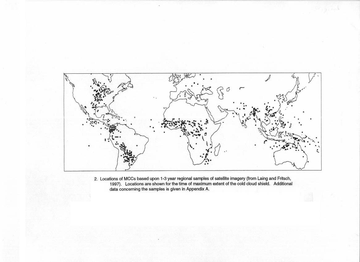
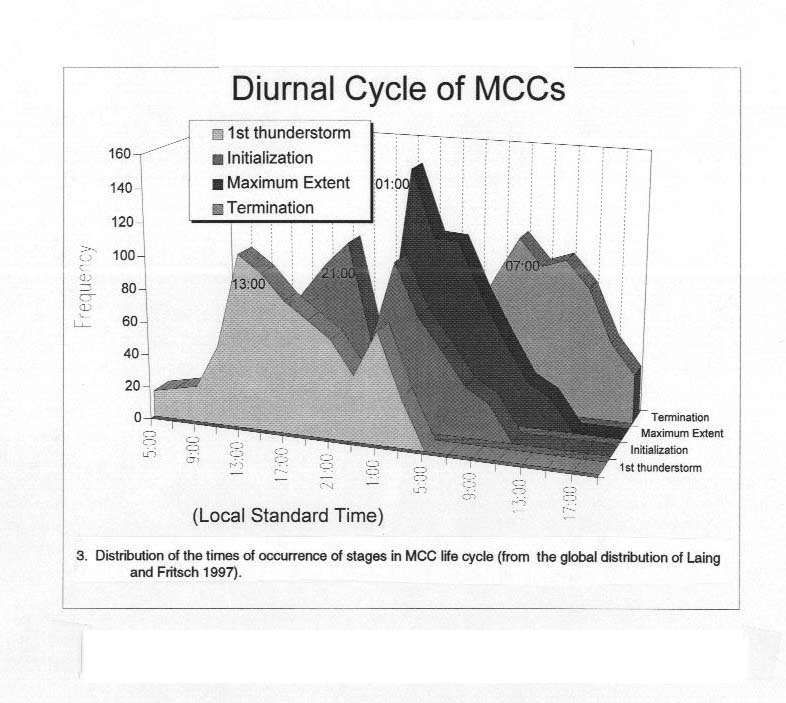
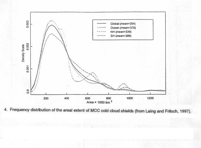
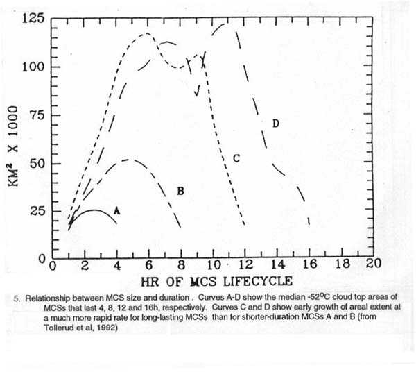
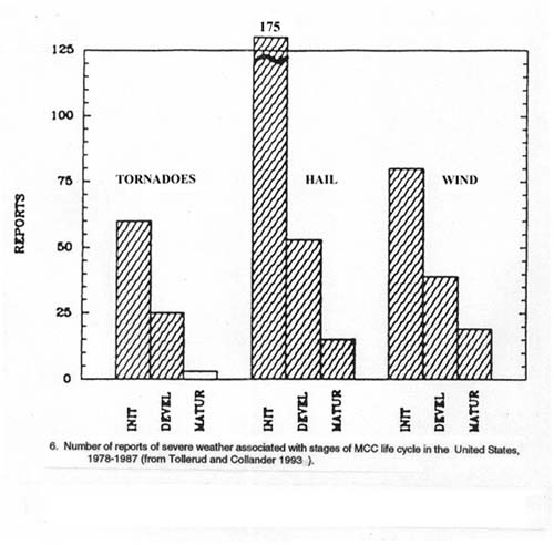
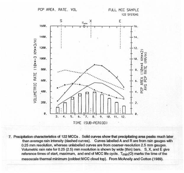
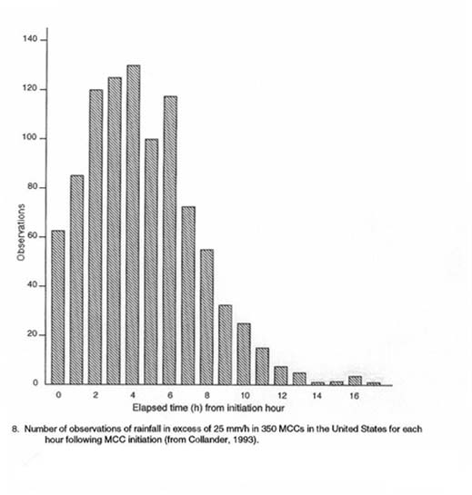
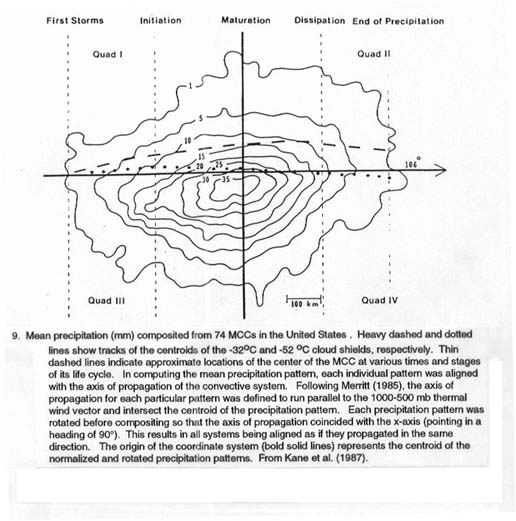
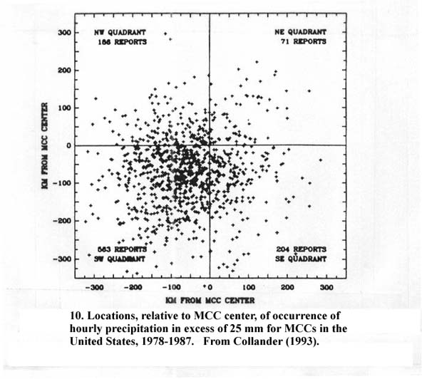
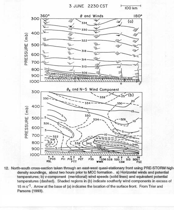
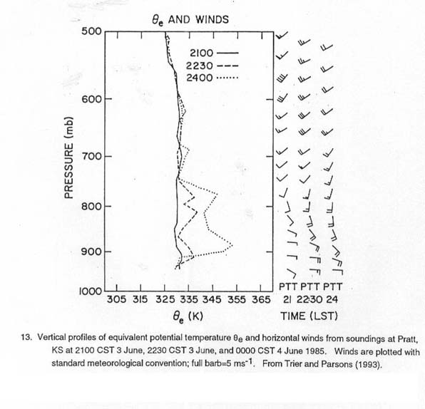
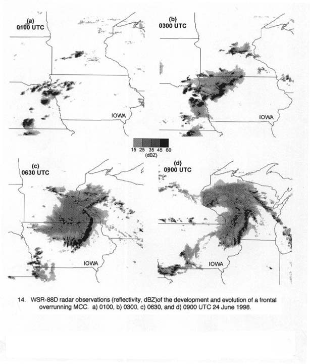
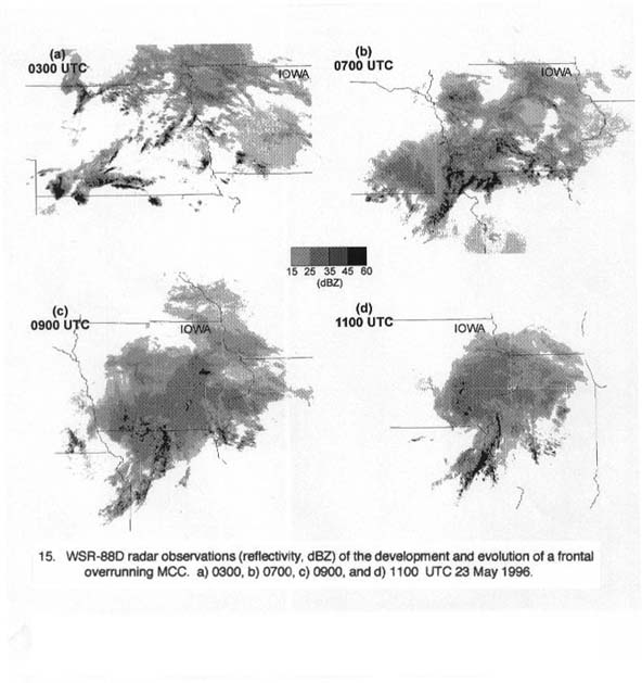
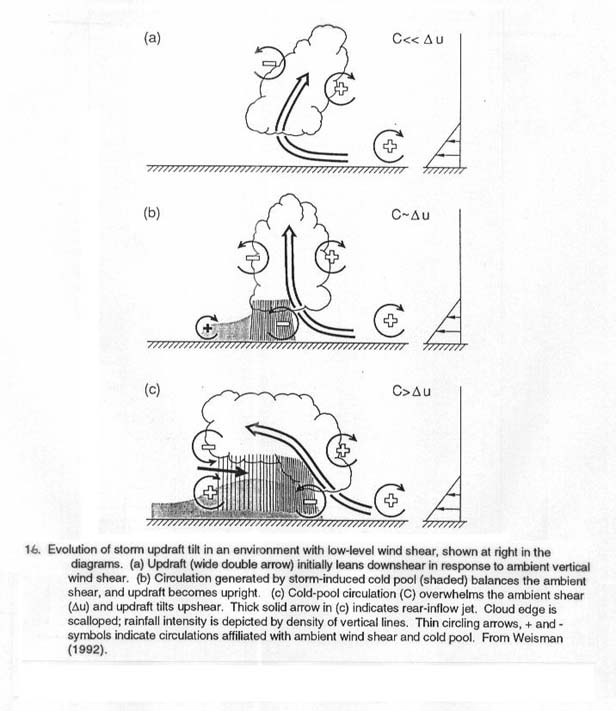
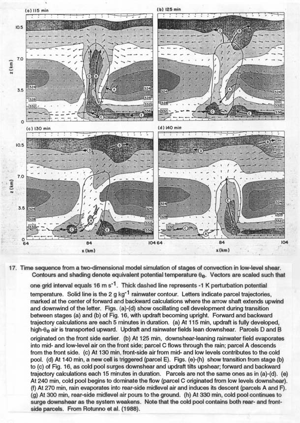
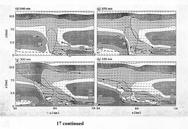
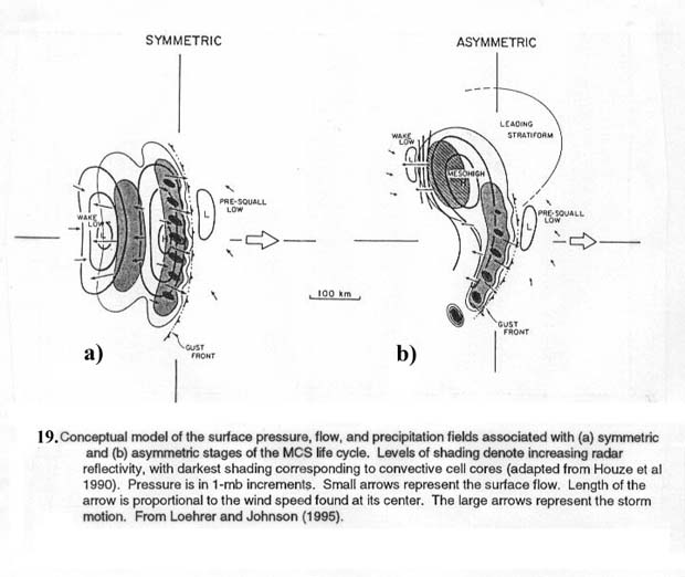
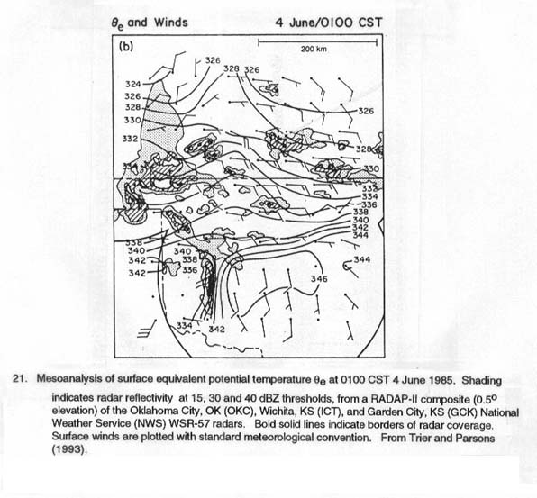
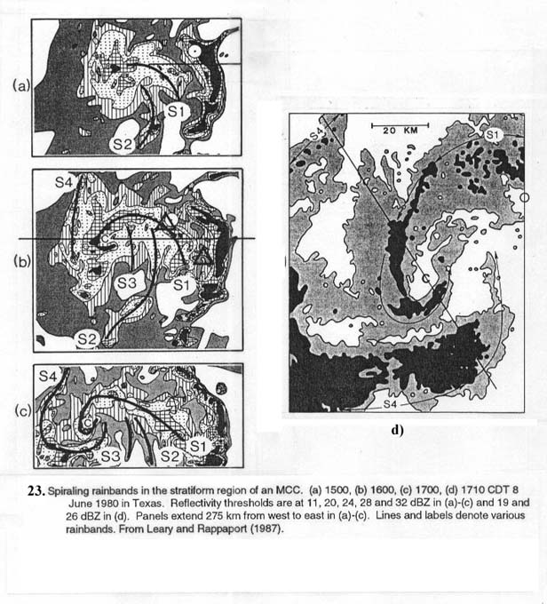
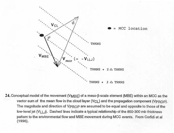
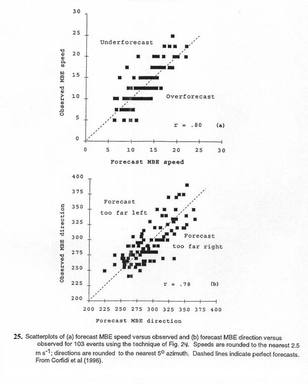
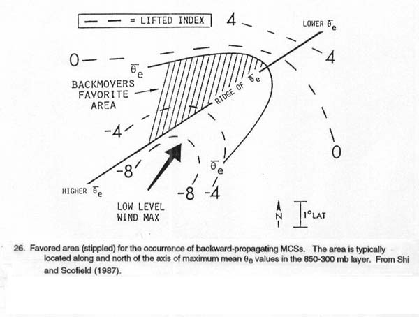
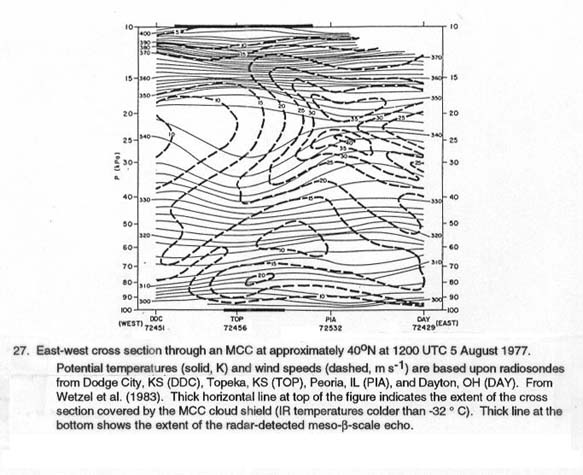
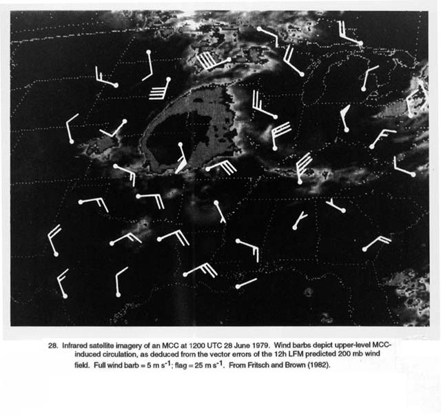
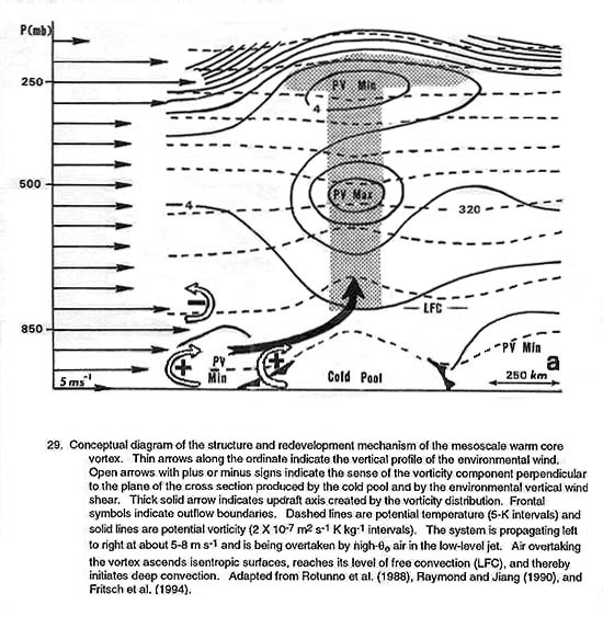
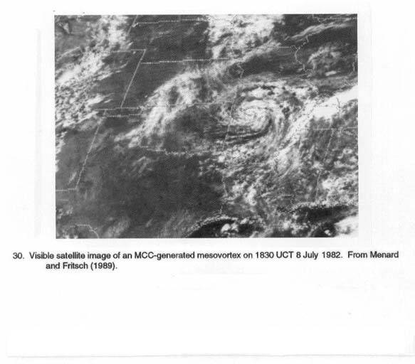
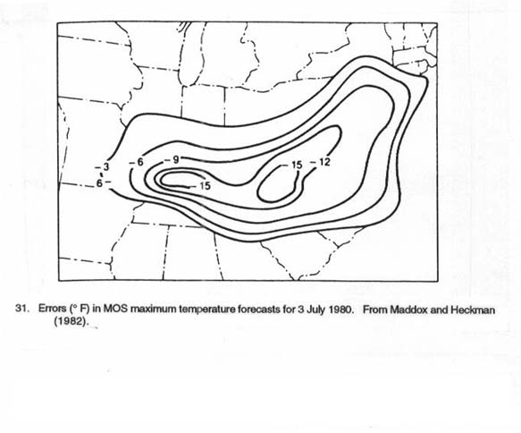
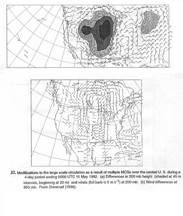