
| | | | Chapter 2
INTERPRETING SATELLITE IMAGERY

Goals: To get hands-on experience interpreting visible, infrared, and
water vapor satellite imagery. A brief summary of guidelines for interpreting
clouds on satellite images is given below. |
SUMMARY OF GUIDELINES FOR INTERPRETING CLOUDS ON SATELLITE IMAGERY
Low Clouds
The base of a deck of low clouds typically looks rather
dark, which means that a limited amount of visible light is getting through.
Thus, a significant amount of sunlight must be reflected (scattered)
back to space by low clouds. Thus, low clouds look bright on visible images.
On infrared images, low clouds appear gray because their tops are relatively warm.
Low clouds are typically not represented on water vapor images because they
are too low in the atmosphere to be detected.
Cirrus Clouds
From the ground, a layer of thin cirrus clouds usually looks white,
meaning that sufficient sunlight is getting through to make their
bottoms rather bright to an observer on the ground. So, because ample
sunlight is getting through, the amount of sunlight that is reflected (scattered)
back to space by cirrus must be somewhat less than what is reflected back by
more reflective low clouds. Thus, cirrus look just a bit off-white
(compared to low clouds) on visible imagery.
On infrared images, cirrus clouds appear white because their tops are very
cold (they are high in the atmosphere).
Cirrus usually appear white on water vapor images because their high-altitude
ice crystals emit "cold" 6.7 micron radiation.
Tall cumulus clouds or Cumulonimbus clouds
From the ground, the base of a cumulonimbus cloud usually appears
very dark, which means that little visible light is getting through.
Thus, such thick
clouds must be reflecting (scattering) a large amount of visible light back
to space, so tall cumulonimbus clouds appear bright white on
visible images.
The high tops of cumulonimbus clouds are cold and thus appear bright white
on infrared imagery.
The high tops of cumulonimbus clouds appear white on water vapor
images because their high-altitude ice crystals emit "cold" 6.7 micron
radiation.
Data:
Visible, infrared, color-enhanced infrared, and water vapor imagery
for several cases, plus high-resolution visible imagery.
Case 1:
Comparing visible, infrared, water vapor, and enhanced infrared:
A typical case
Case 2:
Comparing visible, infrared, water vapor, and enhanced infrared:
Tropical Storm Ignacio
Case 3:
High-resolution visible imagery and albedo: Salt Flats, mountains,
and snow
Case 4:
Comparing visible and infrared imagery: Ship trails and Erica
Case 5:
The usefulness of water vapor imagery: Low-level muggies
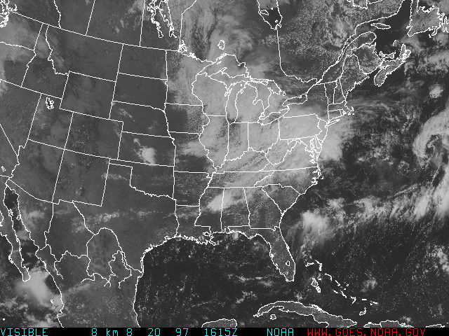
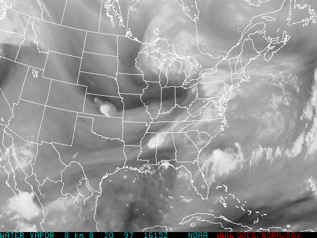
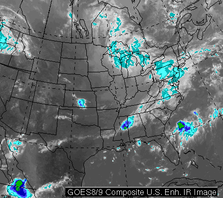
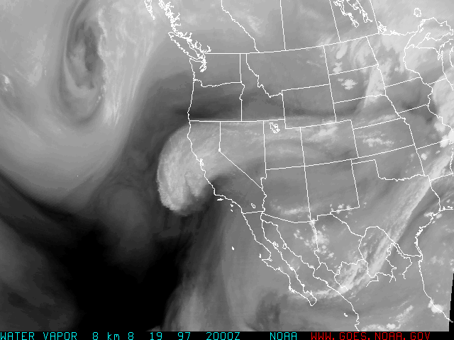
CASE 1
The following satellite images were taken at 16Z on August 20, 1997:
Visible,
Infrared,
Water Vapor,
Enhanced Infrared.
Use these images to answer the following questions:
- Looking at the water vapor image,
is the air at high altitudes over northwestern
Ohio dry or moist? Explain your reasoning.
- Looking at the visible image,
are there clouds over northwestern Ohio? Argue, using only
information from the water vapor image and
the visible image, why these clouds are probably low clouds.
- Substantiate your answer to the previous question
using the infrared image.
- Look again at the water vapor image.
Note the narrow swath of moist air aloft that extends from central
Texas to the lower Mississippi Valley and
into the central Appalachians. Note the bright blob (which represents
clouds) in Mississippi. Do you think that this blob represents cumulonimbus
clouds (thunderstorms) or a patch of thick, high cirrus (feathery
ice-crystal) clouds? Look at the enhanced
infrared image and frame your answer based on this image.
Also make your case using the visible image.
Hint: For comparison sake, there are streamers of cirrus clouds moving
into western Montana from southwestern Canada.
- Use one of the images to decide what surface, land or water, has
the higher albedo (on average) with respect to radiation in the
range of wavelengths
from 0.4 micrometers to 0.7 micrometers. Which image did you use?
CASE 2
The following satellite images were taken at 20Z on August 19,
1997, as the remains of Tropical Storm Ignacio approached
the California coast:
Visible,
Infrared,
Water Vapor,
Enhanced Infrared.
Overnight on August 19, the remnants of Ignacio brought
0.72 inches of rain to San Francisco, barely missing the
all-time MONTHLY rainfall for August (previously, the record
for the month of August was 0.78 inches set in 1976 - weather
records at San Francisco began in 1850). At Sacramento, CA,
it was the first time it ever rained on August
20 since weather records began in 1877.
Use these images to answer the following questions:
- Look first at the water vapor image,
on which the fuzzy
countenance of the remnants of Ignacio can be seen along the coast of
central California. Ignacio subsequently moved into the Pacific Northwest,
bringing rain to parts of Oregon and Washington. From this direction of
movement, we can assume that the high-altitude winds that were steering
weather systems at the time were blowing rather swiftly from the
south-southwest. Based on this assumption, what would you forecast for San
Francisco for later in the day and at night - breaking clouds or just plain cloudy?
What feature on the water vapor image would have likely arrived
and influenced San Francisco later that day and at night. Explain.
- Now look at the infrared image.
It is difficult to say, at first
glance, whether there are any clouds along and just off the coasts of
Baja California and southern California (south of the remnants of
Ignacio). By looking at another type of satellite image, can you
be more specific about whether there are clouds are not?
Which image did you use to decide?
- Now look again on the infrared image
at the clouds over the Pacific Ocean west of
the remnants of Ignacio. Do these Pacific clouds have lower or higher
cloud tops than the clouds associated with the remnants of Ignacio?
Explain your answer.
- Now peruse the enhanced infrared image.
Considering the entire span
of this image, where are the coldest tops located? Based on its shape,
this feature likely represents a cluster of thunderstorms (cumulonimbus
clouds). At the same time, there were also thunderstorms associated with
the remnants of Ignacio. Of these two thundery areas, which probably
contained the more potent thunderstorms (assume that the taller the
thunderstorms, the more powerful they are). Explain your answer in
terms of cloud-top temperatures.
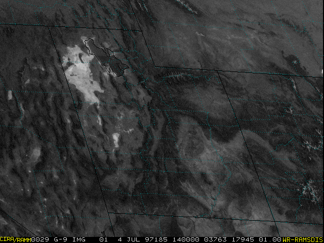
CASE 3
- Consider this high resolution
visible satellite image which
shows the Bonneville Salt Flats in Utah, taken on
July 4, 1997. At one time in earth's long and illustrious history,
the Great Salt Lake covered a much larger
area of Utah than it does today. As the waters of the lake
receded, large deposits of salt were left behind, helping
to create the famous Bonneville Salt Flats, seen in the image as the
very bright blob west of the Great Salt Lake. What
characteristic of salt is responsible for the Flats
appearing so bright on this image?
- Now look near the Utah-Wyoming border. There is a dark splotch
in Utah than spans from east to west. This splotch is the Uinta
Mountains. If you look closely, there are tiny veins of white
that ripple
north-south through the Uintas. What do you think these veins
of white represent? Explain.
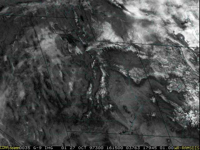
- Now consider another
high resolution visible satellite image
of Utah, this one taken in the aftermath of the blizzard that struck
the central
Rockies on October 24-25, 1997. You will learn in a future
chapter that snow is usually heaviest atop tall mountains, given
that moist air is forced to ascend to great altitudes, a perfect
route for making heavy snow. Based on what you see, pick out the
Wasatch Range by giving the direction of the mountain
chain's orientation (east-west, northwest-southeast, etc). Note
that part of the Wasatch chain is visible from Salt Lake City.
------------------------------------------
In visible images, it is sometimes difficult to tell the difference
between clouds and snow on the ground (under mostly clear skies). Of
course, if you have access to a sequence of visible images, clouds will
typically move in time while snow cover won't. On the other hand,
while looking at a single visible image, meteorologists can determine
whether a blotch of white is snow cover by identifying rivers or
lakes, which early in the cold season, are ice- and snow-free and
therefore appear as dark fingers amidst white snow cover.
- Consider the linear swath of white stretching from Colorado
to Iowa on this
visible image taken on October 28, 1997.
Within this white swath, there are telltale signs that this is
mostly snow cover and that the sky is actually mostly clear over
the Great Plains. Look in eastern Nebraska.
Is there any feature that looks like a river? If so, consult an atlas
and give the name of the river.
- On the same visible image,
now look at Iowa. There is a finger of dark that stretches
toward the southeastern corner of the state. Is this a river
within a snowpack? If so, name the river.
- This swath of snow was produced by a storm that dumped 21.9
inches of snow at Denver's Airport on Friday and Saturday,
October 24-25, 1997. Most of eastern Colorado was also hard hit.
Can you find a river in Eastern Colorado? If so, describe where
it is and give its name.
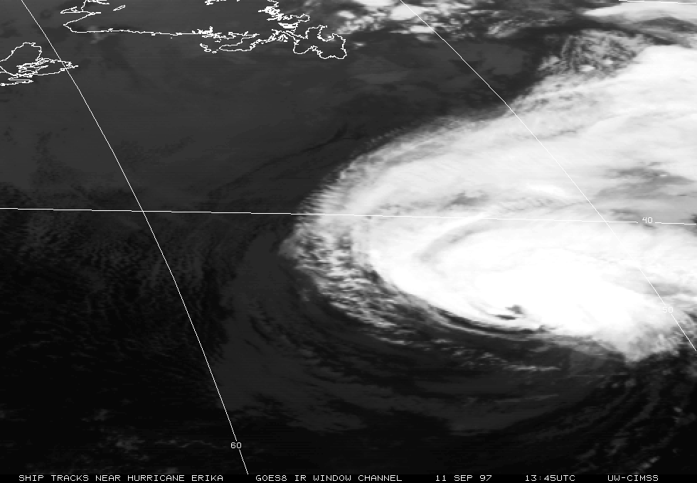
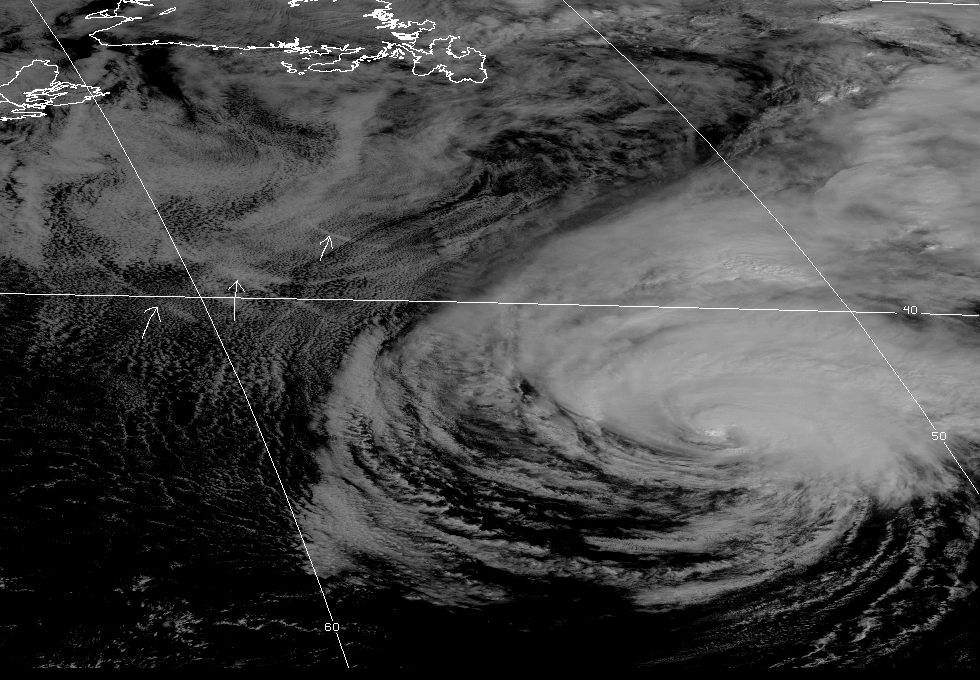
CASE 4
You are given
infrared and
visible images of the remnants
of Hurricane Erika as it churned across the North Atlantic Ocean on
September 15, 1997. If you look closely at the
visible image,
there are a few streaks of white to the west and northwest of Erika
(the white arrows point to a few of these streaks).
These streaks are formed from the emissions of ships (presumably
steering out of the way of Erika). Combustion particles in these
"ship trails" promote abundant, small droplets of water as water
vapor in the emissions condenses onto them. In other words, these
ship trails are a kind of low-level cloud. It turns out
that clouds made of abundant small water droplets reflect more
sunlight than
if they were comprised of fewer larger water drops.
That's why ship trails
stand out in visible satellite images (of course, the environment
must also be somewhat humid so that the ship trails can persist
long enough to be photographed from space).
Now look at the
infrared image taken at the same time. The ship
trails are not evident. Putting your knowledge of infrared cloud
imagery to work, can you explain why the streaks do not stand out
from other low clouds in the vicinity?
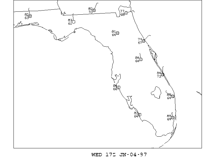
CASE 5
Consider this
water vapor image taken at 17:15Z
on June 4, 1997. Note the dark swath that stretches from the
Gulf of Mexico across the peninsula of Florida and out over the
Atlantic Ocean. Some television weathercasters have pointed to
similar swaths and pronounced "The air is dry"!
Now inspect the
surface weather map at 17Z, showing
station models. Consider closely the locations in Florida that are
within the dark swath shown in the previous water vapor image.
The number to the lower left of the cloud circle in the station
model is called the dew point. The dew point is an absolute
measure of the amount of water vapor in the air (that is, the higher
the dew point, the more water vapor in the air). We will
study the dew point in detail in Chapter 5, but for now, be
advised that dew points in the 65-70oF range indicate
that the surface air contains rather high levels of water vapor.
Yet the water vapor image suggests that "the air is dry."
Explain this apparent paradox.
Other "Weather on the Web" Exercises
Chapter 1 |
Chapter 3 |
Chapter 8 |
Chapter 9 |
Chapter 10|
Chapter 11 |
Chapter 12 |
Chapter 14