

The ocean–sediment system and stratigraphic modeling in large basins
Bernd J. Haupt
Sonderforschungsbereich 313, Universität Kiel, Heinrich–Hecht–Platz 10, D–24118 Kiel, Germany
Karl Stattegger
Geologisch–Paläontologisches Institut, Universität Kiel, Olshausenstraße 40–60, D–24118 Kiel, Germany
The figures, animations and table shown here are supplementary material to the book chapter with the same name [PDF].
Additionally , we show several animations of our results published in the paper "SEIDOV, D. AND HAUPT, B. J., 1997, Simulated ocean circulation and sediment transport in the North Atlantic during the last glacial maximum and today: Paleoceanography, v. 12/2, p. 281–305." The animations show simulated sedimentation patterns, trajectories of water parcels, and settling of the particles in the North Atlantic for three different time slices: the Holocene/Modern (HM), the meltwater event (MWE) near 13.5 ka B.P , and the last glacial maximum (LGM) near 18 ka B.P.
Figures
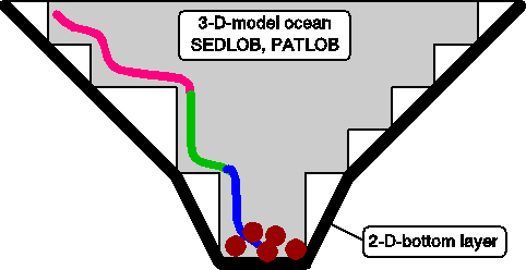
Figure 1. Coupling of the two submodels
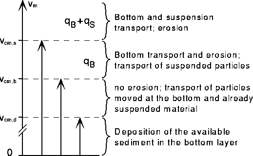
Figure 2. Critical velocities for initiating bed load transport and suspension load transport (see Figure 3). The formula for calculating the bed load transport is qB where D* and p~0.7 and for calculating the suspension transport is qS.
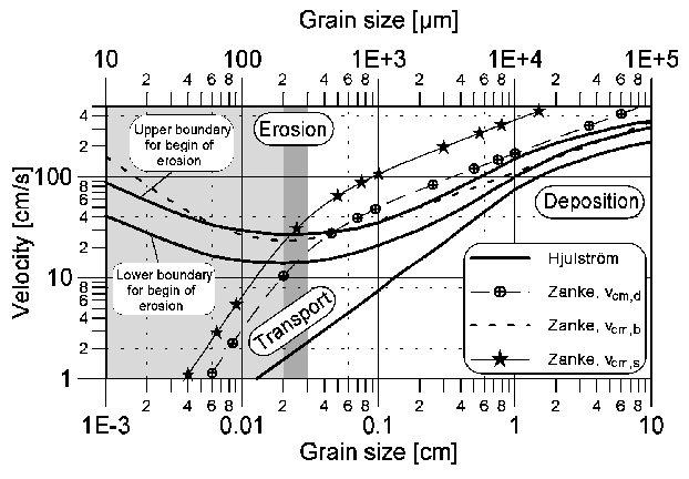
Figure 3. Critical velocities for initiating bed load and suspension load transport. The well known Hjulström (1935) curve is given as reference curve. The critical velocities for initiating of deposition (vcm,d), of bed load transport (vcm,b), and suspension load transport (vcm,s) are approximated by polynomial equations given in Zanke 1977.
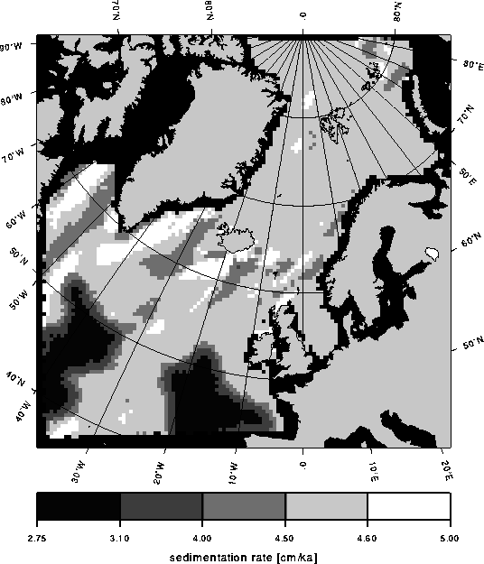
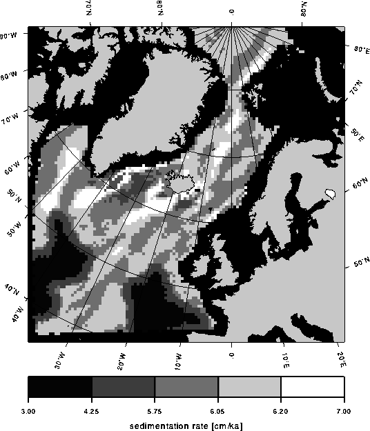
Figure 4. (a) Present–day and (b) LGM sedimentation rate (centimeters/1000 years). Only the eolian sediment input from the atmosphere (1x10-13 g/cm2s ~ 0.0864 mg/cm2d) is considered (Miller et al., 1977; Honjo, 1990). The critical velocities for starting of bed load and for beginning of suspension load are set to 0.05 cm s-1.
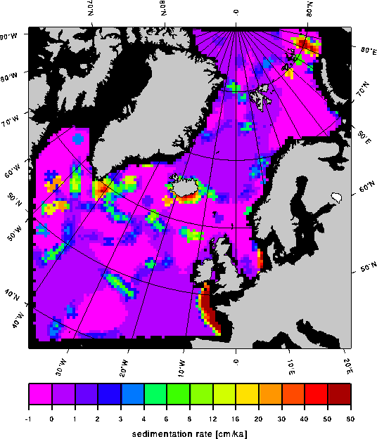
Figure 5. Present–day sedimentation rate (centimeters/1000 years). In comparison to experiment HM1 (Fig. 4a) additional lateral sediment sources from rivers and coastal melting icebergs are included (Haupt, 1995; Haupt et al., 1997). Furthermore, the critical velocities for starting of bed load and for beginning of suspension load are decreased to 0.002 cm s-1 respectively 0.02 cm s-1 to initiate higher transports.
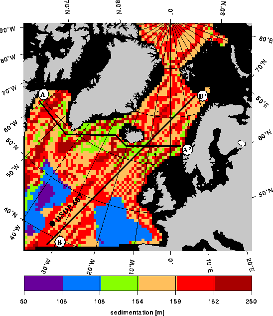
Figure 6. Time–integration and stacking of glacial and interglacial sediment patterns, scenario 1. This scenario uses the sedimentation pattern shown in Figure 4a for the interglacial, and the one shown in Figure 4b for the glacial state. Additionally the location of the cross–sections A–A' and B–B' (see Figure 8 and Figure 9), and the location of the North Atlantic site DSDP 607 are shown.
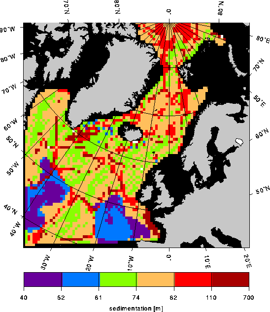
Figure 7. Time–integration and stacking of glacial and interglacial sediment patterns, scenario 2. This scenario uses the sedimentation pattern shown in Figure 5 for the interglacial and that shown in Figure 4b for the glacial state.
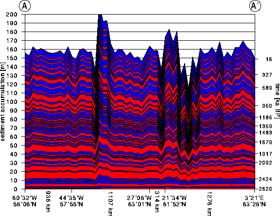
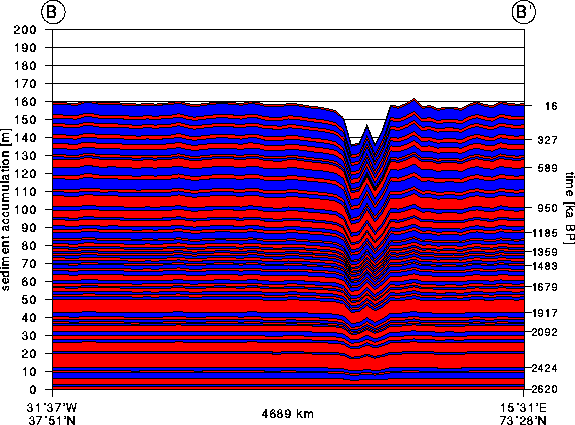
Figure 8. Synthetic stratigraphy (a) along the Greenland–Iceland–Faeroer–Scotland Ridge and (b) from the Mid–Atlantic Ridge to the border of the Barents shelf in scenario 1 (see text). The cross–sections A–A' and B–B' are shown in Figure 6.
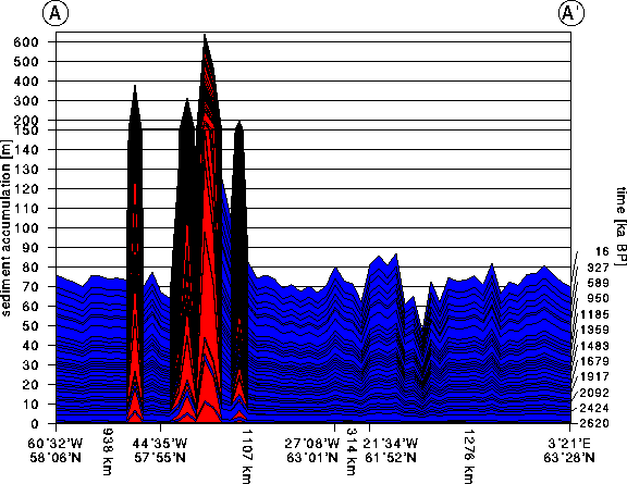
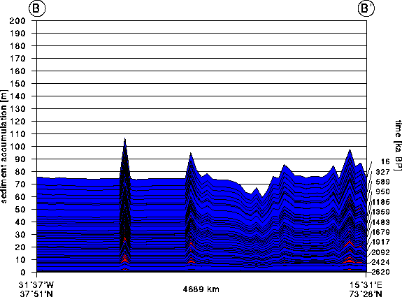
Figure 8. Synthetic stratigraphy (a) along the Greenland–Iceland–Faeroer–Scotland Ridge and (b) from the Mid–Atlantic Ridge to the border of the Barents shelf in scenario 2 (see text). The cross–sections A–A' and B–B' are shown in Figure 6.
Animations
| 525 frames (58 seconds) | Figure 8a | Figure 8b | Figure 9a | Figure 9b |
| 263 frames (32 seconds) | Figure 8a | Figure 8b | Figure 9a | Figure 9b |
| 105 frames (15 seconds) | Figure 8a | Figure 8b | Figure 9a | Figure 9b |
Table
Table 1: A continuous time sequence of 33 cold and 34 warm periods covering the last 2.62 Ma years was filtered out from the North Atlantic site DSDP 607 (Ruddiman et al., 1989; Raymo et al. 1989). On the base of the oxygen isotope curve (running mean) Mudelsee and Stattegger (1997) took only periods with a minimum duration of 15000 years, that will contribute noticeably in the build–up of the sediment column.
| Climatic Period | Age in ka | Duration in ka |
| warm | 0–16 | 16 |
| cold | 16–113 | 97 |
| warm | 113–143 | 30 |
| cold | 143–194 | 51 |
| warm | 194–223 | 29 |
| cold | 223–294 | 71 |
| warm | 294 –327 | 33 |
| cold | 327–374 | 47 |
| warm | 374–421 | 47 |
| cold | 421–477 | 56 |
| warm | 477–497 | 20 |
| cold | 497–516 | 19 |
| warm | 516–589 | 73 |
| cold | 589–662 | 73 |
| warm | 662–697 | 35 |
| cold | 697–790 | 93 |
| warm | 790–817 | 27 |
| cold | 817–853 | 36 |
| warm | 853–950 | 97 |
| cold | 950–983 | 33 |
| warm | 983–1052 | 69 |
| cold | 1052–1072 | 20 |
| warm | 1072–1128 | 56 |
| Climatic period | Age in ka | Duration in ka |
| cold | 1128–1159 | 31 |
| warm | 1159–1185 | 26 |
| cold | 1185–1242 | 57 |
| warm | 1242–1259 | 17 |
| cold | 1259–1290 | 31 |
| warm | 1290–1319 | 29 |
| cold | 1319–1336 | 17 |
| warm | 1336–1359 | 23 |
| cold | 1359–1377 | 18 |
| warm | 1377–1396 | 19 |
| cold | 1396–1420 | 24 |
| warm | 1420–1445 | 25 |
| cold | 1445–1468 | 23 |
| warm | 1468–1483 | 15 |
| cold | 1483–1518 | 35 |
| warm | 1518–1538 | 20 |
| cold | 1538–1575 | 37 |
| warm | 1575–1624 | 49 |
| cold | 1624–1655 | 31 |
| warm | 1655–1679 | 24 |
| cold | 1679–1695 | 16 |
| warm | 1695–1729 | 34 |
| cold | 1729–1754 | 25 |
| Climatic period | Age in ka | Duration in ka |
| warm | 1754–1775 | 21 |
| cold | 1775–1801 | 26 |
| warm | 1801–1917 | 116 |
| cold | 1917–1960 | 43 |
| warm | 1960–1985 | 25 |
| cold | 1985–2006 | 21 |
| warm | 2006–2022 | 16 |
| cold | 2022–2037 | 15 |
| warm | 2037–2092 | 55 |
| cold | 2092–2131 | 39 |
| warm | 2131–2166 | 35 |
| cold | 2166–2191 | 25 |
| warm | 2191–2278 | 87 |
| cold | 2278–2296 | 18 |
| warm | 2296–2424 | 128 |
| cold | 2424–2454 | 30 |
| warm | 2454–2471 | 17 |
| cold | 2471–2525 | 54 |
| warm | 2525–2576 | 51 |
| cold | 2576–2595 | 19 |
| warm | 2595–2620 | 25 |
Animations of the North Atlantic
Click images to trigger animations.

Sedimentation rate (centimeters/1000 year) facilitated by the Holocene/Modern circulation pattern. The animation covers a period of 1000 years. The sedimentological settings are similar to thoose described in "The ocean–sediment system and stratigraphic modeling in large basins (see this volume)".
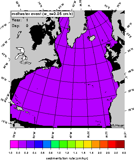
Sedimentation rate (centimeters/1000 year) facilitated by the meltwater event circulation pattern. The animation covers a period of 1000 years. The sedimentological settings are similar to thoose described in "The ocean–sediment system and stratigraphic modeling in large basins (see this volume)".

Sedimentation rate (centimeters/1000 year) facilitated by the last glacial maximum circulation pattern. The animation covers a period of 1000 years. The sedimentological settings are similar to thoose described in "The ocean–sediment system and stratigraphic modeling in large basins (see this volume)".
The following animations show trajectories of particles deployed in the western subtropical gyre of the North Atlantic for three time slices (H/M water parcels, MWE water parcels, LGM water parcels). All trajectories are calculated with the impact of the convection included (H/M convection, MWE convection, LGM convection). The first 150 years of the particles history are shown. The depth is indicated by colors from the color palette; as the particle descends or upwells, the color of the trajectory changes. The length of the particles tail show the paths during one year. Additionally, they are an indicator for the speed.
The following three animations show the same particles with an additionally settling velocity of 0.13 centimeter/day: H/M sediment particles, MWE sediment particles, LGM sediment particles.